Qualified dating range attached to an analysis value.
Storage for analysis values that represents a dating range.
Core analysis value record attached to an analysis entity.
Stores results from an analysis as a (untyped) string value.
Represents analysis entities, which are virtual constructs allowing the association of multiple proxies with a single physical sample. This enables the linking of physical samples to various measurements or counts across different methods. Analysis Entities are organized by datasets, which are constructed based on proxy requirements. Refer to the 'Dataset' documentation for more details.
Free-text note attached to an analysis value.
Storage for notes associated to an analysis value.
Dimension measurement attached directly to an analysis value.
Storage for dimension of analysis value.
Defines the dimensions applicable to each coordinate system method and specifies any legal values for these dimensions. Each entry associates a coordinate system method with its corresponding dimensions and their permissible value ranges.
Contains measurable dimension data for samples, excluding coordinates. This includes attributes such as volume, weight, and depth within stratigraphy or cores.
See tbl_dimensions for the list of different types of dimensions that are recorded in SEAD
Dimension measurement attached directly to an analysis value.
Storage for dimension of analysis value.
Stores dimensional measurements of samples, such as weight before and after burning, volume, or other similar metrics.
Represents analysis entities, which are virtual constructs allowing the association of multiple proxies with a single physical sample. This enables the linking of physical samples to various measurements or counts across different methods. Analysis Entities are organized by datasets, which are constructed based on proxy requirements. Refer to the 'Dataset' documentation for more details.
Stores dimensional measurements of samples, such as weight before and after burning, volume, or other similar metrics.
Records continuous chemical or physical values related to specific sample analyses. Each Sample Analysis can have zero or one associated Measured Value.
Contains definitions of various measurement types, such as sample weight and core length, categorized by method group.
Method group 14
standard measurements
| dimension_id | dimension_abbrev | dimension_name | dimension_description | unit_id |
|---|---|---|---|---|
| 1 | w | Weight | Sample weight | 2 |
| 3 | NULL | Sample/core width | Width of entire sample or (square) core width | 1 |
| 4 | h | Height | Height of sample | 1 |
| 5 | v | Volume | Sample volume | 3 |
| 6 | d | Core diameter | Diameter of core | 1 |
| 44 | Tree diameter (m) | Tree diameter in metres | Diameter of tree sampled for dendrochronological and/or climatological investigation. | 1 |
sample layer position measurements
| dimension_id | dimension_abbrev | dimension_name | dimension_description | unit_id |
|---|---|---|---|---|
| 2 | NULL | Lower boundary depth from unknown reference | Depth of lower sample boundary from unknown or unspecified reference level | 1 |
| 19 | NULL | Positive boundary depth from surface upper | Positive values denote depth of upper sample/unit/core etc boundary from ground or water surface in metres. | 1 |
| 20 | NULL | Upper boundary depth (negative) from surface | Negative values denote depth of upper sample/unit/core etc boundary from ground or water surface in metres. | 1 |
| 21 | NULL | Lower boundary depth (positive) from surface | Positive values denote depth of lower sample/unit/core etc boundary from ground or water surface in metres. | 1 |
| 22 | NULL | Lower boundary depth (negative) from surface | Negative values denote depth of lower sample/unit/core etc boundary from ground or water surface in metres. | 1 |
| 23 | NULL | Upper boundary depth (positive) from reference | Positive values denote depth of upper sample/unit/core etc boundary from reference line (e.g. profile line, core top), reference point or datum, in metres. | 1 |
| 24 | NULL | Upper boundary depth (negative) from reference | Negative values denote depth of upper sample/unit/core etc boundary from reference line (e.g. profile line, core top), reference point or datum, in metres. | 1 |
| 25 | NULL | Lower boundary depth (positive) from reference | Positive values denote depth of lower sample/unit/core etc boundary from reference line (e.g. profile line, core top), reference point or datum, in metres. | 1 |
| 26 | NULL | Lower boundary depth (negative) from reference | Negative values denote depth of lower sample/unit/core etc boundary from reference line (e.g. profile line, core top), reference point or datum, in metres. | 1 |
| 27 | NULL | Upper boundary depth from unknown reference | Depth of upper sample boundary from unknown or unspecified reference level | 1 |
| 43 | Sampling height (cm) | Sampling height in centimetres | Height at which a sample was retrieved. Positive values denotes distance measured from the ground-level. | 16 |
ceramics measurements
| dimension_id | dimension_abbrev | dimension_name | dimension_description | unit_id |
|---|---|---|---|---|
| 28 | h | Vessel height | Vessel height | 1 |
| 29 | NULL | Firing temperature (min) | Minimum firing temperature required for creation of ceramic object | 9 |
| 30 | NULL | Base diameter | Vessel base diameter | 1 |
| 32 | NULL | Melting point | Approximate ceramics melting point | 9 |
| 31 | NULL | Rim diameter | Vessel rim diameter | 1 |
| 33 | NULL | Melting point higher than | Temperature at which ceramic vessel melting point was measured but not achieved. E.g. >1350 | 9 |
| 34 | Sherd thickness | Sherd thickness (mm) | Thickness of a sherd of burnt clay, measured in millimeters | 10 |
| 35 | Base minimum | Base diameter (cm) minimum | Vessel base diameter in centimeters, minimum size measurement | 16 |
| 36 | Base maximum | Base diameter (cm) maximum | Vessel base diameter in centimeters, maximum size measurement | 16 |
| 37 | Rim minimum | Rim diameter (cm) minimum | Vessel rim diameter in centimeters, minimum size measurement | 16 |
| 38 | Rim maximum | Rim diameter (cm) maximum | Vessel rim diameter in centimeters, maximum size measurement | 16 |
| 39 | Sherd minimum | Sherd thickness (mm) minimum | Vessel sherd thickness in millimeters, minimum size measurement | 10 |
| 40 | Sherd maximum | Sherd thickness (mm) maximum | Vessel sherd thickness in millimeters, maximum size measurement | 10 |
| 41 | Height minimum | Vessel height (cm) minimum | Vessel height in centimeters, minimum | 16 |
| 42 | Height maximum | Vessel height (cm) maximum | Vessel height in centimeters, maximum | 16 |
Method Group 17: Sample Coordinates
| dimension_id | dimension_abbrev | dimension_name | dimension_description | unit_id |
|---|---|---|---|---|
| 7 | X/N | X/North | X coordinate or Northing in metres. Negative values are south of the origin (zero coordinate). | 1 |
| 9 | X/N | X/North | X coordinate or Northing in intrinsic units. Negative values are south of the origin (zero coordinate). | 5 |
| 10 | X/E | X/East | X coordinate or Easting in metres. Negative values are west of the meridian or origin (the origin (0/0)). | 1 |
| 11 | X/E | X/East | X coordinate or Easting in intrinsic units. Negative values are west of the meridian or origin (zero coordinate). | 5 |
| 12 | X/E | X/East | X coordinate or Easting in decimal degrees. Negative values are west of the meridian or origin (zero coordinate). | 4 |
| 13 | Y/N | Y/North | Y coordinate or Northing in metres. Negative values are south of the origin (zero coordinate). | 1 |
| 14 | Y/N | Y/North | Y coordinate or Northing in intrinsic units. Negative values are south of the origin (zero coordinate). | 5 |
| 15 | Y/E | Y/East | Y coordinate or Easting in metres. Negative values are west of the meridian or origin (zero coordinate). | 1 |
| 16 | Y/N | Y/North | Y coordinate or Northing in decimal degrees. Negative values are west of the meridian or origin (zero coordinate). | 4 |
| 17 | Y/E | Y/East | Y coordinate or Easting in intrinsic units. Negative values are west of the meridian or origin (zero coordinate). | 5 |
| 18 | Z/Alt | Z/Altitude | Z coordinate or Altitude in metres. | 1 |
Central repository for storing bibliographic references in the SEAD database. It stores detailed citations, including author, title, year, publisher, and DOI/URL for various sources such as books and articles. This table connects to domain-specific tables via foreign keys, ensuring data integrity and supporting research by centralizing bibliographic information.
Organizes collections of analysis entities into datasets, which are structured collections relevant to the specific proxy being studied. For biological proxies, a dataset typically corresponds to a spreadsheet containing samples and taxa for a single analysis method, such as phosphates through citric acid extraction.
- This needs connecting to the metadata tables, figure out which are child and which parent
Numerical range stored in the SEAD
numrangecolumn format and attached to an analysis value.Storage for analysis values that represents a numerical range.
Identifier string attached to an analysis value.
Storage for identifiers associated to analysis values, or analysis value that represents an identifier.
Numerical analysis result with an optional qualifier symbol.
Storage for analysis values that represents a numerical.
Specifies definitions of measurement units (e.g., mm for millimeters).
Contains collections of related samples, typically grouped by structures (e.g., House 1), stratigraphic sequences (e.g., profile 3), or lake cores. Groups can be defined flexibly based on research needs.
Boolean analysis result recorded as a typed child row of an analysis value.
Stores analysis values that represent a boolean (true/false) condition.
Analytical value class describing a data column or measurement family.
Specifies a value class describing e.g. a data column
Dendrochronology value classes
| value_class_id | value_type_id | parent_id | name | description |
|---|---|---|---|---|
| 1 | 8 | NULL | Tree species | Species name of the tree the sample came from. |
| 2 | 1 | NULL | Tree rings | Number of measured tree rings inferred as years. |
| 3 | 12 | NULL | Earlywood/Latewood | A notation in case the outermost ring is not complete. +ew in case only earlywood is present, -lw in case some part of the latewood is missing |
| 4 | 1 | NULL | Number of analysed radii. | Number of analysed radii. |
| 5 | 3 | NULL | EW/LW measurements | Record of whether the earlywood and latewood of each ring has been measured separately. |
| 6 | 1 | NULL | Sapwood (Sp) | Number of sapwood rings, which is the outer layers of a tree, between the heartwood and cambium. |
| 7 | 3 | NULL | Bark (B) | Whether bark was present in the sample. |
| 8 | 13 | NULL | Waney edge (W) | The last formed tree ring before felling or sampling. Presence of this represents the last year of growth. |
| 9 | 1 | NULL | Pith (P) | Number of rings missing between the core of the tree and the first measured ring. |
| 10 | 5 | NULL | Tree age ≥ | The analysed age of the tree. |
| 11 | 5 | NULL | Tree age ≤ | The analysed age of the tree. |
| 12 | 6 | NULL | Inferred growth year ≥ | The growth year inferred from the analysed tree rings. |
| 13 | 6 | NULL | Inferred growth year ≤ | The growth year inferred from the analysed tree rings. |
| 14 | 10 | NULL | Estimated felling year | The felling year as inferred from the analysed outermost tree-ring date |
| 15 | 10 | NULL | Possible estimated felling year | Used for samples where dating has not been succesful but a non-statistically satisfactory dating suggestion is given. |
| 16 | 7 | NULL | Provenance | The provenance of the sampled tree, inferred by comparing the sample with others. |
| 17 | 10 | NULL | Outermost tree-ring date | The date of the outermost tree-ring |
| 18 | 3 | NULL | Not dated | Used to mark samples as not having been succesfully dated, i. e. analysed but not dated |
| 19 | 7 | NULL | Date note | Notes on a sample. |
| 20 | 7 | NULL | Provenance comment | Comments on the provenance of a sample |
| 21 | 1 | NULL | Non-measured tree rings | Estimated number of non-measured tree rings outside the outermost measured tree ring. |
| 22 | 1 | NULL | Non-measured sapwood rings | Estimated number of non-measured sapwood rings outside the outermost measured tree ring1 |
| 24 | 10 | NULL | Innermost tree-ring date | The date of the innermost tree-ring |
| 23 | 1 | 6 | Sapwood indicator | Indicates if sample has sapwood, which is the outer layers of a tree, between the heartwood and cambium. |
Ancient DNA analysis value classes
| value_class_id | value_type_id | parent_id | name | description |
|---|---|---|---|---|
| 43 | 17 | NULL | Molecular sex - Rx | Prediction of molecular sex of individual. Rx is based on the ratio of reads aligning to the X chromosome and autosomes. |
| 42 | 9 | NULL | mtDNA haplogroup | Prediction of mitochondrial DNA haplogroup. |
| 41 | 9 | NULL | Y haplogroup | Prediction of Y chromosome haplogroup. |
| 40 | 9 | NULL | 1st deg. relatives | List of sample IDs that are 1st degree relatives to the analysed individual. |
| 39 | 9 | NULL | 2nd deg. relatives | List of sample IDs that are 2nd degree relatives to the analysed individual. |
| 38 | 9 | NULL | >2nd deg. relatives | List of sample IDs that are further than 2nd degree relatives to the analysed individual. |
| 37 | 14 | NULL | Library preparation(s) | Type of sequence library preparation (e.g. blunt-end, single-stranded, etc.). |
| 36 | 16 | NULL | Damage treatment(s) | Type of damage treatment if applicable (e.g. UDG). |
| 35 | 15 | NULL | SNP capture | Type of SNP capture if applicable (e.g. 1240k). |
| 34 | 7 | NULL | Metagenomics analysis | Record of whether the library been subjected to a metagenomic analysis. |
| 54 | 9 | NULL | Organism genome mapped to | Organism whose reference sequence / genome assembly was used for sequence alignment. |
| 53 | 9 | NULL | Reference genome assembly | reference sequence / genome assembly name or accession code. |
| 52 | 1 | NULL | Endogenous reads (filtered) | The number of sequence reads which have successfully mapped to the organism reference sequence after filtering. |
| 51 | 11 | NULL | Average read length | The average length of mapped sequence reads, excluding reads shorter than 35 bases and reads with less than 90% consensus to the species reference. |
| 50 | 11 | NULL | Average depth of coverage - genome (x) | The number of times on average that a given nucleotide in the genome has been sequenced. |
| 49 | 4 | NULL | Breadth of coverage - genome (%) | The percentage of the reference sequence / genome assembly covered after alignment. |
| 48 | 11 | NULL | Average depth of coverage - mtDNA (x) | The number of times on average that a given nucleotide in the mitochondrial genome has been sequenced. |
| 47 | 2 | NULL | mtDNA reads | The number of sequence reads which have successfully mapped to the mitochondrial DNA in the reference sequence. |
| 46 | 2 | NULL | X chromosome reads | The number of sequence reads which have successfully mapped to the X chromosome in the reference sequence. |
| 45 | 1 | NULL | Y chromosome reads | The number of sequence reads which have successfully mapped to the Y chromosome in reference sequence. |
| 44 | 17 | NULL | Molecular sex - Ry | Prediction of molecular sex of individual. Ry is based on the ratio of reads aligning to the X and Y chromosomes. |
| 33 | 9 | NULL | General library file name | General file name suffix for library DNA sequence fastq files, BAM files, etc. |
| 32 | 1 | NULL | Merged reads | The total number of merged sequence reads retained following adapter removal and merging of read pairs. |
| 31 | 2 | NULL | Endogenous reads (raw) | The number of sequence reads which have successfully mapped to the organism reference sequence before filtering. |
| 30 | 4 | NULL | Raw endogenous content (%) | The number of sequence reads which have successfully mapped to the organism reference sequence after filtering. |
| 29 | 4 | NULL | Duplicate reads (%) | The percentage of mapped sequence reads that are PCR duplicates i.e. they have identical start and end positions. |
| 28 | 4 | NULL | Short reads (%) | The percentage of mapped sequence reads that are shorter than 35 bases. |
| 27 | 11 | NULL | 5’ damage | Proportion of T nucleotides (given C nucleotide in reference) at the 5’ end of sequence reads. Representative of damage to DNA due to deamination of cytosines. |
| 26 | 11 | NULL | 3’ damage | Proportion of A nucleotides (given G nucleotide in reference) at the 3’ end of sequence reads. Representative of damage to DNA due to deamination of cytosines on complementary strand. |
| 25 | 7 | NULL | Methods metadata download link | Link to methods metadata worksheet (with lab and bioinformatics methods, tools, parameters, etc.). |
Categorical analysis result linked to a controlled value-type item.
Storage for analysis values that represents a categorical value.
Qualified integer range attached to an analysis value.
Storage for analysis values that represents an integer range.
Integer-valued analysis result with an optional qualifier symbol.
Storage for analysis values that represents an integer value.
Taxon-specific count attached to an analysis value.
Storage for analysis values that represents a taxon counts.
Contains definitions of various measurement types, such as sample weight and core length, categorized by method group.
Method group 14
standard measurements
| dimension_id | dimension_abbrev | dimension_name | dimension_description | unit_id |
|---|---|---|---|---|
| 1 | w | Weight | Sample weight | 2 |
| 3 | NULL | Sample/core width | Width of entire sample or (square) core width | 1 |
| 4 | h | Height | Height of sample | 1 |
| 5 | v | Volume | Sample volume | 3 |
| 6 | d | Core diameter | Diameter of core | 1 |
| 44 | Tree diameter (m) | Tree diameter in metres | Diameter of tree sampled for dendrochronological and/or climatological investigation. | 1 |
sample layer position measurements
| dimension_id | dimension_abbrev | dimension_name | dimension_description | unit_id |
|---|---|---|---|---|
| 2 | NULL | Lower boundary depth from unknown reference | Depth of lower sample boundary from unknown or unspecified reference level | 1 |
| 19 | NULL | Positive boundary depth from surface upper | Positive values denote depth of upper sample/unit/core etc boundary from ground or water surface in metres. | 1 |
| 20 | NULL | Upper boundary depth (negative) from surface | Negative values denote depth of upper sample/unit/core etc boundary from ground or water surface in metres. | 1 |
| 21 | NULL | Lower boundary depth (positive) from surface | Positive values denote depth of lower sample/unit/core etc boundary from ground or water surface in metres. | 1 |
| 22 | NULL | Lower boundary depth (negative) from surface | Negative values denote depth of lower sample/unit/core etc boundary from ground or water surface in metres. | 1 |
| 23 | NULL | Upper boundary depth (positive) from reference | Positive values denote depth of upper sample/unit/core etc boundary from reference line (e.g. profile line, core top), reference point or datum, in metres. | 1 |
| 24 | NULL | Upper boundary depth (negative) from reference | Negative values denote depth of upper sample/unit/core etc boundary from reference line (e.g. profile line, core top), reference point or datum, in metres. | 1 |
| 25 | NULL | Lower boundary depth (positive) from reference | Positive values denote depth of lower sample/unit/core etc boundary from reference line (e.g. profile line, core top), reference point or datum, in metres. | 1 |
| 26 | NULL | Lower boundary depth (negative) from reference | Negative values denote depth of lower sample/unit/core etc boundary from reference line (e.g. profile line, core top), reference point or datum, in metres. | 1 |
| 27 | NULL | Upper boundary depth from unknown reference | Depth of upper sample boundary from unknown or unspecified reference level | 1 |
| 43 | Sampling height (cm) | Sampling height in centimetres | Height at which a sample was retrieved. Positive values denotes distance measured from the ground-level. | 16 |
ceramics measurements
| dimension_id | dimension_abbrev | dimension_name | dimension_description | unit_id |
|---|---|---|---|---|
| 28 | h | Vessel height | Vessel height | 1 |
| 29 | NULL | Firing temperature (min) | Minimum firing temperature required for creation of ceramic object | 9 |
| 30 | NULL | Base diameter | Vessel base diameter | 1 |
| 32 | NULL | Melting point | Approximate ceramics melting point | 9 |
| 31 | NULL | Rim diameter | Vessel rim diameter | 1 |
| 33 | NULL | Melting point higher than | Temperature at which ceramic vessel melting point was measured but not achieved. E.g. >1350 | 9 |
| 34 | Sherd thickness | Sherd thickness (mm) | Thickness of a sherd of burnt clay, measured in millimeters | 10 |
| 35 | Base minimum | Base diameter (cm) minimum | Vessel base diameter in centimeters, minimum size measurement | 16 |
| 36 | Base maximum | Base diameter (cm) maximum | Vessel base diameter in centimeters, maximum size measurement | 16 |
| 37 | Rim minimum | Rim diameter (cm) minimum | Vessel rim diameter in centimeters, minimum size measurement | 16 |
| 38 | Rim maximum | Rim diameter (cm) maximum | Vessel rim diameter in centimeters, maximum size measurement | 16 |
| 39 | Sherd minimum | Sherd thickness (mm) minimum | Vessel sherd thickness in millimeters, minimum size measurement | 10 |
| 40 | Sherd maximum | Sherd thickness (mm) maximum | Vessel sherd thickness in millimeters, maximum size measurement | 10 |
| 41 | Height minimum | Vessel height (cm) minimum | Vessel height in centimeters, minimum | 16 |
| 42 | Height maximum | Vessel height (cm) maximum | Vessel height in centimeters, maximum | 16 |
Method Group 17: Sample Coordinates
| dimension_id | dimension_abbrev | dimension_name | dimension_description | unit_id |
|---|---|---|---|---|
| 7 | X/N | X/North | X coordinate or Northing in metres. Negative values are south of the origin (zero coordinate). | 1 |
| 9 | X/N | X/North | X coordinate or Northing in intrinsic units. Negative values are south of the origin (zero coordinate). | 5 |
| 10 | X/E | X/East | X coordinate or Easting in metres. Negative values are west of the meridian or origin (the origin (0/0)). | 1 |
| 11 | X/E | X/East | X coordinate or Easting in intrinsic units. Negative values are west of the meridian or origin (zero coordinate). | 5 |
| 12 | X/E | X/East | X coordinate or Easting in decimal degrees. Negative values are west of the meridian or origin (zero coordinate). | 4 |
| 13 | Y/N | Y/North | Y coordinate or Northing in metres. Negative values are south of the origin (zero coordinate). | 1 |
| 14 | Y/N | Y/North | Y coordinate or Northing in intrinsic units. Negative values are south of the origin (zero coordinate). | 5 |
| 15 | Y/E | Y/East | Y coordinate or Easting in metres. Negative values are west of the meridian or origin (zero coordinate). | 1 |
| 16 | Y/N | Y/North | Y coordinate or Northing in decimal degrees. Negative values are west of the meridian or origin (zero coordinate). | 4 |
| 17 | Y/E | Y/East | Y coordinate or Easting in intrinsic units. Negative values are west of the meridian or origin (zero coordinate). | 5 |
| 18 | Z/Alt | Z/Altitude | Z coordinate or Altitude in metres. | 1 |
Contains the physical dimensions of a sample group (e.g., core length) based on a specified dimension type.
Contains information about the physical dimensions of samples used for analysis, including both analyzed samples and non-analyzed residues.
Categorizes various analysis methods into groups based on their similarities, such as dating methods, isotope analyses, palaeoentomology, or geographic location.
List copied 2026-04-20 from https://browser.sead.se/postgrest/tbl_methods)
| method group | group name |
|---|---|
| 1 | Palaeobiological |
| 2 | Palaeo chemical/physical |
| 3 | Dating by radiometric methods |
| 4 | Modern biological |
| 9 | Biological/Chemical/Physical |
| 13 | Sampling |
| 14 | Size measurement |
| 15 | Colour |
| 16 | Preparation method |
| 17 | Coordinate and altitude systems |
| 18 | Soil horizons |
| 19 | Dating to period |
| 20 | Dating to calendar year(s) |
| 21 | Dating by other method |
| 22 | Dating by radiation exposure methods |
Contains collections of related samples, typically grouped by structures (e.g., House 1), stratigraphic sequences (e.g., profile 3), or lake cores. Groups can be defined flexibly based on research needs.
Records information about physical samples collected from specific sites. Each sample is characterized by its location within the site, its physical properties measured in specific units (e.g., liters, kilograms), and its context within a sample set. Additionally, samples may have descriptive information, notes, and external identifiers linked to other systems.
Specifies the physical location data of samples. This includes both local grid references and standardized global coordinates, such as latitude and longitude. References a methods that determines the type of grid used, facilitating the plotting of samples on large-scale maps or site-specific projects.
Represents analysis entities, which are virtual constructs allowing the association of multiple proxies with a single physical sample. This enables the linking of physical samples to various measurements or counts across different methods. Analysis Entities are organized by datasets, which are constructed based on proxy requirements. Refer to the 'Dataset' documentation for more details.
Establishes a many-to-many relationship between samples and specific features, allowing a feature to be related to multiple samples and a sample to be linked to multiple features. This supports scenarios where samples originate from nested feature groups or features with multiple identifiers.
Contains information about the colors related to physical samples.
Represents geographical locations, typically defined by regions. These can be current or historical locations.
Defines the types of alternative references or names assigned to samples. These references might include identifiers like lab numbers, field numbers, museum numbers, or site excavation numbers, indicating the origin or purpose of the sample’s alternative reference.
| alt_ref_type_id | alt_ref_type | description |
|---|---|---|
| 3 | Lab number | Sample number/name used by the lab which performed the analyses or managed the samples for analysis. Note: this is NOT use for radiocarbon laboratories, which are recorded in the Structure of SEAD/Columns/lab_number field of tbl_geochronology |
| 4 | Other alternative sample name | Any other form of reference used in the sample documentation. |
| 5 | Archaeological excavation sample number | Sample number used on-site during archaeological excavation, and relating to excavation documentation. |
| 6 | Field number | Sampling number used during field survey. |
| 1 | Museum number | Sample number/name used by a museum. Include prefix if present. |
| 2 | Contractor sample number | Sample number/name used by contractor, as submitted to lab or extracted from site documentation. Include prefix if present. |
| 7 | Trap number | Number/name of the insect/sediment etc trap. |
| 8 | Quadrat or grid number | Survey grid unit number. |
| 9 | Museum subnumber | Local identification used by a museum. |
| 10 | Find number | Identification used in the field for artifacts |
| 11 | Compound ID | SEAD identification made by concatenating two, or more, existing identifications |
| 12 | Bugs sample code | Unique identifier for (physical) samples in the BugsCEP database |
| 14 | Sequence Library ID | Sequence library ID code (generated by ADU). Identifies one of multiple possible libraries generated for a DNA sample. |
| 13 | Associated DNA library ID | DNA library ID associated with a sample |
Defines the physical form or category of a sample. This can include specific sub-samples related to the sampling method of a sample group, or general bulk samples. Examples include ‘Core Subsample’, ‘Grab Sample’, and ‘Bulk (Bag) Sample’.
[! abstract] my suggested edit for this:
Defines the physical form or category of a sample from a sampling method perspective. Examples include ‘Core Subsample’, ‘Grab Sample’, and ‘Bulk (Bag) Sample’, but also ‘Field measurement’ and even ‘Photograph’. For more specific information about the physical sample itself, see tbl_record_types and tbl_abundance_elements
| sample_type_id | type_name | description |
|---|---|---|
| 1 | Bulk sample | Sample in a container such as bag, box. |
| 2 | Kubiena subsample | Unit of sediment extracted from a kubiena box |
| 3 | Core subsample | Unit of sediment extracted from a core |
| 4 | Monolith subsample | Unit of sediment extracted from a monolithic soil/peat sample |
| 5 | Tent trap contents | Contents of tent trap(s), any trap bulking details in notes. |
| 6 | Pitfall trap contents | Contents of pitfall trap(s), any trap bulking details in notes. |
| 7 | Modern insect collection | Sample from field sampling or hunting of insects (e.g. contents of a tube) |
| 8 | Modern vegetation collection | Vegetation survey sample unit. |
| 9 | Unspecified | Sample type not known or documented |
| 10 | Dendro cross-cut sample | Cross-cut disc used for dendrochronology analysis |
| 11 | Dendro cross-cut wedge sample | Cross-cut wedge shaped sample used for dendrochronolgy analysis |
| 12 | Dendro core sample | Wood core sample used for dendrochronolgy analysis |
| 13 | Field measurement | Values measured in field without physical sample (e.g. metal detector, MS-loop, fluxgate magnetometer) |
| 14 | Dating pseudosample | Virtual sample consisting of aggregated material from multiple samples to bulk up weight for radiocarbon dating (or other dating method) |
| 16 | Ceramic sherd | A sherd originating from any type of ceramic object |
| 20 | Photograph | Sample consists of a photograph which has been the basis for measurements (e.g. photograph of dendrochronological cross-section). |
| 21 | Tracing | A thin paper is placed on the sample surface and a pencil is used to trace the features (e.g. in dendrochronology used to trace the ring-width pattern onto the paper). |
| 22 | Poster putty | Poster putty is applied to the surface of the sample in order to create an imprint (e.g. in dendrochronology used to imprint the ring-width sequence). |
Proposed new sample types
| sample_type_id | type_name | description |
|---|---|---|
| (new) | Dating Sample | The portion of a physical sample analysed for radiocarbon dating (or other dating method) |
Contains information about the locations of samples based on predefined types.
Contains miscellaneous notes related to samples that do not belong in other tables, such as ‘stored in a cellar until processing in 2020’.
Contains detailed descriptions of samples categorized by different description types.
Contains images related to samples, including site photographs, lab processing images, and microscope images.
Contains various reference names for physical samples, such as laboratory or field numbers.
Raidocarbon dating lab numbers do not go in this table
They belong in tbl_geochronology
Contains measurable dimension data for samples, excluding coordinates. This includes attributes such as volume, weight, and depth within stratigraphy or cores.
See tbl_dimensions for the list of different types of dimensions that are recorded in SEAD
Contains bibliographic information specifically relevant to a sample group, distinct from site or dataset references (e.g., a publication that reinterprets a structure within a site).
Contains information about data related to specific sites that is not currently stored in SEAD. Each record corresponds to a distinct proxy type, even if multiple proxies are linked to the same publication. Note that some of these datasets might be integrated into SEAD in the future. Requests for data submission can be directed to the SEAD project team.
Associates ecological classifications with specific taxa.
Central repository for storing bibliographic references in the SEAD database. It stores detailed citations, including author, title, year, publisher, and DOI/URL for various sources such as books and articles. This table connects to domain-specific tables via foreign keys, ensuring data integrity and supporting research by centralizing bibliographic information.
Contains definitions for ecological, habitat, or ethnographic categories, which are linked to specific taxa within a defined classification system.
Represents the finest level of taxonomic classification, typically at the species level. It may also include designations such as ‘sp.’ for an unspecified single species, ‘spp.’ for multiple unspecified species, ‘grp’ for taxonomic groups, or split identifications (e.g., x/y), along with other cases depending on the taxonomic context.
Contains rarity data for taxa within specific geographical areas (e.g., threatened species in Sweden).
Definitions of rarity categories across various systems, as specified in tbl_rdb_systems.
Details of rarity designation systems (commonly known as Red Data Books) and the regions where they are applicable.
Contains descriptive distribution information for taxa, along with references to the source publications. For example, ‘Scandinavia north of Tromsø, British Isles - rare.’
Central repository for storing bibliographic references in the SEAD database. It stores detailed citations, including author, title, year, publisher, and DOI/URL for various sources such as books and articles. This table connects to domain-specific tables via foreign keys, ensuring data integrity and supporting research by centralizing bibliographic information.
Stores identification key extracts along with their bibliographic sources.
Contains ecological, habitat, and behavioral information for various taxa, along with references to their sources, such as ‘in hollows on old oaks.’
Contains bibliographic references related to the taxonomic ordering or numbering systems. Multiple references may be associated.
Contains alternative scientific names for taxa, along with primary references for their definition or usage.
Represents a major grouping identifier for datasets, typically indicating a contributing database, project, user, or laboratory (e.g., BugsCEP, MAL, Lund Dendro Lab).
Stores bibliographic references that define the accepted authority for a dating period, rather than the dating of a specific sample.
Catalogs publications that describe or mention sites. Publications related to specific sample groups, physical samples, or datasets are documented at their respective hierarchical levels.
Defines various systems used for classifying specific attributes of taxa, including habitat preferences, food types, and cultural uses.
Contains references for geochronological (radiometric) dating of samples.
Details of rarity designation systems (commonly known as Red Data Books) and the regions where they are applicable.
Contains definitions and details of various analysis methods.
The full list of methods
(Sorted by tbl_method_groups, as of 2026-04-20, copied from https://browser.sead.se/postgrest/tbl\_methods)
1. Palaeobiological
| method_id | method_name | description | method_abbrev_or_alt_name |
|---|---|---|---|
| 3 | Palaeoentomology | Primarily fossil insect analyses, although other similar groups are usually included.\nThe method is commonly used for the reconstruction of natural and human environments in archaeological and palaeoecological contexts as well as climate change studies through the Mutual Climatic Range (MCR) method. \nStandard method: \n- samples disaggregated in warm water over a 300µm sieve; \n- excess water removed from sieved residue, then residue mixed with small amount of liquid paraffin (kerosene); \n- cold water added and left to stand for 15 minutes after which the floating (paraffin captured) fraction is pored into a 300µm sieve; \n- latter stage (fill, float, pour) repeated three times; paraffin washed out with detergent and warm water; \n- float is then stored and examined under a binocular microscope usually under 96% alcohol;\n- insect remains and other interesting finds are picked out and identified through the use of reference collections and identification keys.\nNOTE: storage in alcohol most likely has a detrimental effect on the possibility for using insect remains for C14 dating! Any samples where insect remains are to be dated should therefore be only stored in distilled water. | Fossil insects |
| 6 | Chironomid analyses | Non-biting midge (Chironomid) analyses, most commonly performed on lake sediments. | Chirono |
| 8 | Plant macrofossil analyses | The analysis of macro- or microscopic plant remains from either archaeological (archaeobotany) or ‘natural’ contexts.\nStandard method and variations:\n- samples are disaggregated in warm water and washed through a sieve (mesh size varies with application, most commonly 250 or 500µm);\n- material caught in the sieve is then either dried or stored in water/alcohol before sorting under a binocular microscope;\n- specimens are identified with the help of reference collections and identification keys. | Plant macros |
| 14 | Palynology | Pollen analysis. | Pollen |
| 15 | Charcoal analysis | The analysis of burnt/carbonised particles or fragments. | Charcoal |
| 40 | Mollusc analyses | Analysis of either land, fresh water or marine molluscs. | Molluscs |
| 111 | Plant macros (volume) | Plant macrofossil amount quantified by absolute volume | null |
| 175 | Ancient DNA analysis (Sample Extraction/Analysis) | Extraction and analysis of ancient DNA recovered from biological material (human, animal, plants, etc.) | aDNA-Sample |
| 176 | Ancient DNA analysis (Library Preparation) | Library preparation of ancient DNA recovered from biological material (human, animal, plants, etc.) | aDNA-Library |
2. Palaeo chemical/physical
| method_id | method_name | description | method_abbrev_or_alt_name | |
|---|---|---|---|---|
| 32 | Loss on ignition | An evaluation of the proportion of organic matter present in a sample, measured by comparing pre-burnt and post-burnt sample weights.\nStandard method: | LOI | |
| 33 | Magnetic susceptibility | A measurement of the ability of a sample to retain an induced magnetic field. | MS | |
| 35 | Magnetic susceptibility (Low frequency) | A measurement of the ability of a sample to retain a low frequency induced magnetic field. | MS-lo | |
| 36 | Magnetic susceptibility (High frequency) | A measurement of the ability of a sample to retain a high frequency induced magnetic field. | MS-hi | |
| 37 | Phosphate degrees | Amount of phosphates. Standard method: Inorganic phosphate content. Extraction by citric acid (2%). Based on Arrhenius and further developed by EAL. The amount of phosphate is specified as mg P2O5/100g dry soil. | P° | |
| 74 | Total phosphates citric acid | Measurement of total phosphate content through citric acid extraction and photospectrometer | citPtot | |
| 94 | Phosphate degrees HCL | Amount of phosphates. Standard method using HCL instead of citric acid. | P°HCL | |
| 106 | MS loop | Bartington MS2 & MS2D | null | |
| 107 | Conductivity µS (H2O) | Conductivity in µS (H2O) | null | |
| 109 | pH (H2O) | Acidity (pH) | null | 2 |
| 110 | pH (KCl 0,1M) | Acidity (pH) (KCl 0,1M) | null | |
| 118 | 0,6mm (%) | 0,6mm. Extracted through sieving. | Grain size 0,6-2mm (%) | |
| 119 | 0,6mm (%) | 0,6mm. Extracted through sieving. | 0,6 mm (%) |
3. Dating by radiometric methods
| method_id | method_name | description | method_abbrev_or_alt_name |
|---|---|---|---|
| 38 | C14 Accelerator dating | Accelerator Mass Spectrometer Carbon-14 dating. | C14 AMS |
| 39 | C14 Conventional | Conventional Carbon-14 dating. | C14 |
| 146 | U-Series U234/U238 | U234/U238 | |
| 147 | Uranium-Series (general) | U-Series | |
| 148 | Radiocarbon (14C Unspecified) | Dating by a radiocarbon method, the details of which are not provided in the publication or supporting material. | C14 Unspec. |
| 149 | Radiometric date by unknown method | Dating by an unspecified radiometric method (information missing in publication). | UnknownRadio |
| 151 | C14 Conventional | Conventional Carbon-14 dating. Uncalibrated dates. | C14 Std |
| 152 | Amino Acid Racemization | Age determination based on the post-mortem decay (or racemization/epimerization) of amino acids in fossils. The method has primarily been used to date shells, and less sucessfully on bone, teeth and wood under some conditions. | AAR |
| 153 | C14 dating of humic substances in sediment | Age determination by radiocarbon on humic substances extracted by pretreatment of sediments (e.g. peat, colluvium). A number of method variations are applied, aimed at dating different fractions of the sample (as opposed to the bulk dating of organic matter), including: humic acid fraction (alkali soluble) and humin fraction (alkali insoluble). Modern dates are generally determined through AMS, but older dates may have been aquired through standard counting. | C14 Humous |
| 154 | Argon39-Argon40 | Argon39-Argon 40 radiometric dating | Ar39-Ar40 |
| 159 | Interpolated C14 | Dating using the interpolation of 14C dates from other samples (give details in dating notes) | Interp 14C |
| 161 | Helium-Uranium | Dating based on the production of helium during the radioactive decay of uranium and thorium. | He-U |
| 162 | Chlorine 36 | Dating based on the radioactive decay of chlorine 36 | Cl36 |
| 163 | Uranium trend | Dating utilizing disequilibrium in the decay of Uranium-238, Uranium-234 and Thorium 230. | U-Trend |
| 164 | Berylium 10 | Dating based on the radioactive decay of berylium 10. | Be10 |
| 165 | Potassium-Argon | Dating based on the radioactive decay of potassium into argon. | K-Ar |
| 167 | U-Series Pa231/U235 | Dating based on the radioactive decay of uranium-series isotopes protactinium-231 and uranium-235. | Pa231/U235 |
| 168 | Lead 210 | Dating based on the measurement of radioactive isotope lead-210, which is a product of uranium decay. | Pb210 |
| 169 | U-Series Th230/U234 | Dating based on the radioactive decay of uranium-234 to thorium-230, and the degree to which secular equilibrium has been restored between these | Th230/U234 |
| 170 | Fission-Track | Dating based on the trails left in some glassy minerals as a result of the radioactive decay of uranium. | Fis-Track |
4. Modern biological
| method_id | method_name | description | method_abbrev_or_alt_name |
|---|---|---|---|
| 16 | Vegetation survey | Survey of modern (living) vegetation | Veg survey |
9. Biological/Chemical/Physical
| method_id | method_name | description | method_abbrev_or_alt_name |
|---|---|---|---|
| 21 | Non-pollen palynomorphs | Specimens commonly found in association with pollen analyses, and/or incorporated into pollen diagrams. | NPP |
| 117 | 2mm (%) | 2mm. Extracted through sieving. | 2mm (%) |
| 171 | Petrographic microscopy | A piece of the ceramic sherd is cut off, fastened to a microscope slide, ground down to 0,03 mm, and polished. The tempering grains and clay is then studied under a microscope to determine clay content, fraction size, sorting and tempering content. These are all determined ocularly. The max grain size and total percent tempering is determined by marking the tempering grains in a photograph projected from the camera connected to the microscope and calculating in the program. | Petrographic |
| 172 | Thermal analysis | A raw clay sample and a sample of the ceramic sherd, or archaeological sample, is heated in a lab oven in 100 °C intervals, for a total of 30 minutes, up to 1000 °C. The colour change during and after heating is noted and compared to the Munsell Colour Chart to determine the firing temperature and firing atmosphere of the archaeological sample. The samples are then once more heated above 1000 °C, in 50 °C intervals, until they reach their melting point. The assumption for the thermal analysis is that the colour change of the ceramic sample doesn’t occur until after the original firing temperature has been reached. | Thermal |
13. Sampling
| method_id | method_name | description | method_abbrev_or_alt_name |
|---|---|---|---|
| 53 | Core by Russian | Core taken using a Russian Auger | Russian core |
| 56 | Core by freeze corer | Core taken using a freeze corer | Freeze core |
| 57 | Kubiena sample | Samples taken using kubiena boxes | Kubiena |
| 58 | Monolith | Monolith samples from exposed section or excavated pit | Monolith |
| 60 | Grab samples | Samples taken in unspecified, non-rigourous method (e.g. excavator, spade, hands etc.) | Grab samples |
| 61 | Temporary record | Temporary record used for testing data entry where a field is manditory but no data exists as yet… | Temp record |
| 81 | Soil auger or probe | Soil extraction by auger or probe | Auger sample |
| 91 | Dendrochronology Cross-section | A cross section perpendicular to the grain is cut with a saw. | Dendro cross-section |
| 92 | Dendrochronology coring | Dendrochronological information extracted from a piece of wood by coring. | Dendro coring |
| 173 | Ceramics collection | Collection of ceramic samples by unspecified means | Ceramics |
14. Size measurement
| method_id | method_name | description | method_abbrev_or_alt_name |
|---|---|---|---|
| 46 | Volume estimate | Subjective estimation of (sample) volume - usually from bag size or bucket | Volume est. |
| 47 | Distance etc measurement | Distance measures: Height, length, depth or width measured by device | Length measured |
| 48 | Distance etc estimate | Distance measures: Height, length, depth or width estimated | Length est. |
| 51 | Volume measurement | Volume measured accuarately | Volume measured |
15. Colour
| method_id | method_name | description | method_abbrev_or_alt_name |
|---|---|---|---|
| 42 | Munsell Colour\n | Soil colour based on Munsell system.\n | Munsell |
| 44 | Subjective colour (trained) | Subjective colour description by a person qualified in sediment description, or with other experience of judging colour (e.g. artist, paint mixer).\n | Colour trained |
| 45 | Subjective colour (amateur) | Subjective colour description by untrained individual.\n | Colour untrained |
16. Preparation method
| method_id | method_name | description | method_abbrev_or_alt_name |
|---|---|---|---|
| 62 | Paraffin floatation | Reduction of sediment by floatation using paraffin (=kerosine, lysfotogen…). Commonly used for extracting insect remains, especially Coleaoptera… | Paraffin float |
| 65 | Hydroflouric acid treatment | Treatment with hydroflouric acid, generally to remove mineral (silicate) particles from pollen samples prior to slide preparation. | HF-treatment |
| 66 | Centrifugation | High velocity rotation of sample to separate contents by density. | Centrifuge |
| 82 | Heating at 550°C | Sample is heated in an over at 550°C. Generally used to burn off organic matter. | Heating 550 |
| 83 | Water floatation | Reduction of sediment by water floatation. Sample is washed through a seive to remove fine material and retrieve lighter organic matter. | Water floatation |
| 84 | Sieving >300µ retained | Separation through 300 micron sieve. Large fraction saved. | Sieving 300µ |
| 85 | Sieving >250µ retained | Separation through 250 micron sieve. Large fraction saved. | Sieving 250µ |
| 86 | Sieving >500µ retained | Separation through 500 micron sieve. Large fraction retained. | Sieving 500µ |
| 87 | Sieving >2mm retained | Separation through 2 mm sieve. Large fraction saved. | Sieving 2mm |
| 88 | Weak hydroxide solution added | Sample mixed with dilute hydroxide solution to spead up dissaggregation of sample. | Weak OH solution |
| 112 | Sieving 600µ | Preparation method: Sieving through 600µ seive (retaining seive contents) | null |
| 124 | Sieving 1.25mm | Preparation method: Sieving through 1.25mm seive (retaining seive contents) | null |
17. Coordinate and altitude systems
| method_id | method_name | description | method_abbrev_or_alt_name |
|---|---|---|---|
| 67 | UK Ordnance Survey National Grid | The United Kingdom National Grid system, established by the Ordnance Survey under the name OSGB36. | OSGB36 |
| 68 | Irish Grid Reference System | The Irish National Grid System, established by the Ordnance Survey of Ireland. | Irish National Grid |
| 69 | Swedish RT90[2.5 gon V] | Swedish Rikets Nät (National Grid) system. Full name “RT 90 2.5 gon V 0:-15”. X = south-north, Y = west-east. Essentially superceded by SWEREF 99 although still in extensive use.\nSee http://www.lantmateriet.se/templates/LMV\_Page.aspx?id=4766\&lang=EN (NOTE: include URL as biblio link) | RT90[2.5 gon V] |
| 70 | SWEREF 99 TM (Swedish) | Swedish geodetic reference system, based on UTM zone 33N bit extended to include the whole of Sweden.\nCoordinates are generally with decimeters of WGS 84 coordinates for the same place.\nSee http://www.lantmateriet.se/templates/LMV\_Page.aspx?id=4219 | SWEREF 99 TM |
| 71 | SWEREF 99 dd mm | Swedish geodetic reference system for local coordinates (where dd mm are replaced by the appropriate zone meridian.\nNOTE: exactly how we handle the specific zones yet to be discussed - maybe one method entry per zone? | SWEREF 99 dd mm |
| 72 | WGS84 | World Geodetic System.\nSystem is used by the Global Positioning System. | WGS84 |
| 73 | Local project grid | Any coordinate or grid system established for local recording of objects. Includes abstract archaeological site grids with origin (0,0) at any location.\nI available, conversion factors for alignment wiwth standard reference systesm should be given in site notes. | Local grid |
| 76 | Altitude above sea level | Height above sea level. Negative values are under standard sea level. | Alt |
| 77 | Depth from reference level | Depth from reference level. Negative values are above reference level. | Depth from datum |
| 78 | Height from datum | Height from reference level/datum. Negative values are below datum. | Height from datum |
| 79 | Depth from surface | Depth from ground or lake/river surface. Neqative values are above ground. Note: use altitude for relative to standard sea level. | Depth from surface |
| 80 | Height from surface | Height from ground or lake/river surface. Negative values below surface. Note: for heights above standard sea level use altitude. | Height from surface |
| 102 | Rikets höjdsystem 1970 | Rikets höjdsystem 1970. Swedish national altitude system 1970. | null |
| 103 | RT90 5 gon V | Rikets koordinatsystem RT90 5 gon V | null |
| 105 | Local or unknown grid | Site-specific grid or unknown site or sampling grid or coordinate system. | null |
| 108 | Göteborgs kommuns koordinatsystem | Göteborgs kommuns koordinatsystem. Gothenburg municipality coordinate system. | null |
| 113 | Malmö stads koordinatnät | Malmö stads koordinatnät. Malmä city coordinate system. In use until 2008-01-01 | null |
| 114 | WGS84 UTM zone 32 | Global coordinate system zone UTM 32 in WGS84 system. Last Revised: June 2, 1995 Area: World - N hemisphere - 6°E to 12°E - by country | null |
| 115 | Depth from surface lower sample boundary | Depth from surface lower sample boundary (depth is positive) | null |
| 116 | Depth surface to upper sample boundary | Depth from ground surface to upper sample boundary (depth is positive) | null |
| 120 | WGS84 UTM zone 33N | WGS84 UTM zone 33N | null |
| 121 | Rikets höjdsystem 1900 | \nKorrektioner: Ingen landhöjnings- eller tidjordskorrektion | RH 00 |
| 122 | Depth surface to lower sample boundary | Depth from ground surface to lower sample boundary (depth is positive) | null |
| 123 | EUREF89 UTM U32 | Official geodetic datum (reference system/projection) of Norway. UTM zone U32. EUREF89. https://www.kartverket.no/Posisjonstjenester/Kartprojeksjoner/ | null |
| 125 | Upper sample boundary (positive depth) | Upper sample boundary positive | null |
| 126 | Lower sample boundary (positive depth) | Lower sample boundary depth positive | null |
18. Soil horizon
| method_id | method_name | description | method_abbrev_or_alt_name |
|---|---|---|---|
| 97 | ISRIC soil horizons | Soil horizon classification according to strict International Soil Reference and Information Center (ISRIC) guidelines. http://www.isric.org/isric/webdocs/docs/ISRIC\_TechPap19.pdf | ISRIC horizons |
| 98 | FAO soil horizons | Soil horizon classification according to strict Food and Argriculture Organization of the United Nations (FAO) guidelines. ftp://ftp.fao.org/agl/agll/docs/guidel_soil_descr.pdf and http://www.fao.org/docrep/W8594E/w8594e0g.htm for more detailed descriptions. | FAO horizons |
| 100 | Goldberg & Macphail soil horizons | Soil horizon calssification according to Goldberg & Macphail (2006) Practical and theoretical geoarchaeology. Variation and simplification of ISRIC system. | Goldberg & Macphail horizons |
| 101 | Soil horizons by undefined system | Soil horizons given without any specified classification system. | Undefined system horizons |
| 104 | MAL soil horizon classifications | Qualitative soil horizon classifications used by MAL. Derived from: Troedsson, Tryggve & Nykvist, Nils (1973). Marklära och markvård. Stockholm: Almqvist & Wiksell | null |
19. Dating to period
| method_id | method_name | description | method_abbrev_or_alt_name |
|---|---|---|---|
| 127 | Pollen Zonation | Age determined by comparison of pollen flora with reference data. A number of standard regional pollen zones have been determined through the compilation and zonation of multiple pollen profiles. Zonation is general achieved through the identification of significant changes in fauna (e.g. from birch to pine dominated), either manually or through cluster analysis. | PollenZone |
| 128 | Archaeological period calendar years | Age determined by comparison of pollen flora with reference data. A number of standard regional pollen zones have been determined through the compilation and zonation of multiple pollen profiles. Zonation is general achieved through the identification of significant changes in fauna (e.g. from birch to pine dominated), either manually or through cluster analysis. | ArchPerCal |
| 129 | Archaeological period C14 years | Age determined to an archaeological period defined in 14C years. This is a bulk method for numerous techniques for assigning a deposit to a particular cultural period, where the period boundaries have been defined by radiocarbon dating. More specific method details should preferably be given as to how the date has been derived, but may not be available. | ArchPerC14 |
| 130 | Historical Period | Age determined to historical period. More specific method details should preferably be given as to how the date has been derived, but may not be available. | HistPer |
| 131 | Geological calendar period | Age determined to geological period defined in calendar years. More specific method details should preferably be given as to how the date has been derived, but may not be available. | GeolPerCal |
| 132 | Geological C14 period | Age determined to geological period defined in C14 years. More specific method details should preferably be given as to how the date has been derived, but may not be available. | GeolPerC14 |
| 133 | Geological radiometric period | Age determined to geological period defined by radiometric methods but not necessarily radiocarbon (e.g. U-series). More specific method details should preferably be given as to how the date has been derived, but may not be available. | GeolPerRadio |
| 134 | Stratigraphic (Geological) | Dating through strategraphic association, placing the sediment (and enclosed artefacts) in the context of geological layers of known or unknown age. | Strat(Geol) |
| 137 | Artefact typology (calendar years) | Dating by artefact typology with calendar date. The form, design and material of an artefact may allow it to be placed in the context of a known sequence of artefact characteristics (a typological sequence). This allows it to be dated through the assumption that the typologies are correctly and independently dated. There is a slight danger or circular reasoning is the constraints of independent dating are not rigourously enforced, and a tendency for typologies to persist even if evidence suggests that there may be problems. | TypoCal |
| 138 | Artefact typology (radiometric years) | Dating by artefact typology with radiometric date. The form, design and material of an artefact may allow it to be placed in the context of a known sequence of artefact characteristics (a typological sequence). This allows it to be dated through the assumption that the typologies are correctly and independently dated. There is a slight danger or circular reasoning is the constraints of independent dating are not rigourously enforced, and a tendency for typologies to persist even if evidence suggests that there may be problems. | TypoRadio |
| 158 | Geological period (unspecified years) | Age determined to geological period using undefined (or possibly multiple) method(s). | GeolPer |
20. Dating to calendar year(s)
| method_id | method_name | description | method_abbrev_or_alt_name |
|---|---|---|---|
| 10 | Dendrochronology | Dating by comparison of tree-ring sequences. | Dendro |
| 135 | Tephrochronology Calendar | Dating by relation to volcanic ash layer of a known calendar age. | TephraCal |
| 136 | Tephrochronology C14 | Dating by relation to volcanic ash layer dated by radiocarbon. | TephraC14 |
| 139 | Other archaeological dating | Unspecified dating method leading to an archaeological date in calendar years. | ArchCal |
| 140 | Wiggle matching of 14C dates | A sequence of radiocarbon dates may be compared with variation in the C14 calibration curve, and dates nudged so that they align with the curve. The method requires a sequence to be tightly dated and may be especially useful around flatter parts of the calibration curve. User discretion is required. | Wiggle |
| 141 | Lichenometry | Dating method which relies on the predictable growth pattern of some lichen species. Some lichens (e.g. Rhizocarpon geographicum) exhibit colonisation, linear growth and non-linear phases of growth. By calibrating sizes against surfaces of known age (e.g. buildings, grave stones) it is possible to guage the age of exposure of a surface through the sizes of the lichens growing on it. A number of variations exist in terms of how to measure. The method has been applied to historical and archaeological remains as well as to geological features such as erosion surfaces and raised beaches. | Lichen |
| 142 | Calendar date by unknown method | Calendar years derived by unknown or unspecified method. | UnknownCal |
| 143 | Geologically derived calendar date | Derivation of calendar date by reference to geological processes, features or events (e.g. volcanic eruption, earthquake). | GeolCal |
| 144 | Historical Records | Dating based on historical documentation. | HistCal |
| 155 | Archaeological period (unspecified) | Period based dating method leading to a range of potential archaeological dates in unspecified years. | ArchPer |
| 156 | Calibrated radiocarbon date (method unspecified) | Calendar years date provided by the calibration of a radiocarbon age. Exact dating method unspecified. | Cal |
| 157 | Calibrated AMS radiocarbon date | Calendar years date provided by calibration of an AMS radiocarbon age. | CalAMS |
21. Dating by other method
| method_id | method_name | description | method_abbrev_or_alt_name |
|---|---|---|---|
| 145 | Other date by unknown method | Unspecified dating method. | UnknownOther |
| 160 | Electron Spin Resonance | Dating based on the trapped charges of electrons, electron spin resonance dating. | ESR |
| 166 | Orbital Tuning | Dating through the synchronization of events according to Milankovitch cycles, casused by changes in the Earth’s orbit, and their expected effects on climate. | Orb-Tuning |
| 174 | Composite chronology | Chronology derived from a combination of dates using various methods. | Composite chronology |
22. Dating by radi+ation exposure methods
| method_id | method_name | description | method_abbrev_or_alt_name | |
|---|---|---|---|---|
| 150 | Thermoluminescence | Dating using the release of stored energy properties of (mainly sonte) material previously exposed to the sun. | TL | 22 |
Represents geographical locations, typically defined by regions. These can be current or historical locations.
Contains definitions for various geographical terms, specifying their resolution and context (e.g., administrative unit, historical administrative unit, lake, country).
- add the list of different location types here
location_type_id location_type
- 1 Country
- 2 Sub-country administrative region
- 4 Settlement
- 5 Continent
- 7 Aggregate/non-admin geographical region
- 8 Institution
- 9 Water body
- 10 Street address
- 14 Historical administrative unit
- 16 Geographical area
- 17 Archaeological site
- 18 Island
- 19 Historical settlement
- 20 Unprocessed Bugs Transfer
Contains rarity data for taxa within specific geographical areas (e.g., threatened species in Sweden).
Details of rarity designation systems (commonly known as Red Data Books) and the regions where they are applicable.
Contains definitions of ages based on historical periods or calendar events, including age ranges and geographical relevance (e.g., Mesolithic in Sweden).
Additional information, not in the database description of this table, but perhaps it should be:
Relative ages are used to store and search for the interpreted age of a sample or material or site (before present), but not the internal age of an object (e.g. a tree or animal).
Associates site identifiers with location names.
to add somewhere
only geographical objects like socken, by, counties, lakes, regions etc. Archaeological site is not used as a location type in this context, or at least should not be…
Contains information about the specific parts of the year (e.g., Winter, June) during which certain activities or developmental stages of taxa occur (e.g., adult stage from June to August).
Contains collections of related samples, typically grouped by structures (e.g., House 1), stratigraphic sequences (e.g., profile 3), or lake cores. Groups can be defined flexibly based on research needs.
Contains data on the preservation levels and threats to cultural heritage sites. Each record represents a unique preservation status or threat. This information was added at the request of PAN (Polar Archaeology Network) members to support the evaluation of threats to Arctic cultural heritage.
Records detailed information about each excavation or sampling location i.e. a defined location where samples have been collected through excavation.
to add somewhere
Each site can have multiple national identifiers of different types. Many sites will have a Lämningsnummer and an RAÄ-nr. The RAÄ-nr must always a combination of the Socken and number (so concatenate the fields on import). Each identifier should go into a separate record (not with ; in the same field)
Contains information about data related to specific sites that is not currently stored in SEAD. Each record corresponds to a distinct proxy type, even if multiple proxies are linked to the same publication. Note that some of these datasets might be integrated into SEAD in the future. Requests for data submission can be directed to the SEAD project team.
Contains images related to a site, such as site photographs, aerial images, or location maps.
Associates site identifiers with location names.
to add somewhere
only geographical objects like socken, by, counties, lakes, regions etc. Archaeological site is not used as a location type in this context, or at least should not be…
Contains site coordinates using various national grid systems, such as the UK Ordnance Survey National Grid and Swedish SWEREF99. Each site may have coordinates in multiple grid systems (e.g., Swedish RT90 and SWEREF99TM).
Note that this table had not yet been used as of July 2026.
Contains collections of related samples, typically grouped by structures (e.g., House 1), stratigraphic sequences (e.g., profile 3), or lake cores. Groups can be defined flexibly based on research needs.
Contains definitions and details of various analysis methods.
The full list of methods
(Sorted by tbl_method_groups, as of 2026-04-20, copied from https://browser.sead.se/postgrest/tbl\_methods)
1. Palaeobiological
| method_id | method_name | description | method_abbrev_or_alt_name |
|---|---|---|---|
| 3 | Palaeoentomology | Primarily fossil insect analyses, although other similar groups are usually included.\nThe method is commonly used for the reconstruction of natural and human environments in archaeological and palaeoecological contexts as well as climate change studies through the Mutual Climatic Range (MCR) method. \nStandard method: \n- samples disaggregated in warm water over a 300µm sieve; \n- excess water removed from sieved residue, then residue mixed with small amount of liquid paraffin (kerosene); \n- cold water added and left to stand for 15 minutes after which the floating (paraffin captured) fraction is pored into a 300µm sieve; \n- latter stage (fill, float, pour) repeated three times; paraffin washed out with detergent and warm water; \n- float is then stored and examined under a binocular microscope usually under 96% alcohol;\n- insect remains and other interesting finds are picked out and identified through the use of reference collections and identification keys.\nNOTE: storage in alcohol most likely has a detrimental effect on the possibility for using insect remains for C14 dating! Any samples where insect remains are to be dated should therefore be only stored in distilled water. | Fossil insects |
| 6 | Chironomid analyses | Non-biting midge (Chironomid) analyses, most commonly performed on lake sediments. | Chirono |
| 8 | Plant macrofossil analyses | The analysis of macro- or microscopic plant remains from either archaeological (archaeobotany) or ‘natural’ contexts.\nStandard method and variations:\n- samples are disaggregated in warm water and washed through a sieve (mesh size varies with application, most commonly 250 or 500µm);\n- material caught in the sieve is then either dried or stored in water/alcohol before sorting under a binocular microscope;\n- specimens are identified with the help of reference collections and identification keys. | Plant macros |
| 14 | Palynology | Pollen analysis. | Pollen |
| 15 | Charcoal analysis | The analysis of burnt/carbonised particles or fragments. | Charcoal |
| 40 | Mollusc analyses | Analysis of either land, fresh water or marine molluscs. | Molluscs |
| 111 | Plant macros (volume) | Plant macrofossil amount quantified by absolute volume | null |
| 175 | Ancient DNA analysis (Sample Extraction/Analysis) | Extraction and analysis of ancient DNA recovered from biological material (human, animal, plants, etc.) | aDNA-Sample |
| 176 | Ancient DNA analysis (Library Preparation) | Library preparation of ancient DNA recovered from biological material (human, animal, plants, etc.) | aDNA-Library |
2. Palaeo chemical/physical
| method_id | method_name | description | method_abbrev_or_alt_name | |
|---|---|---|---|---|
| 32 | Loss on ignition | An evaluation of the proportion of organic matter present in a sample, measured by comparing pre-burnt and post-burnt sample weights.\nStandard method: | LOI | |
| 33 | Magnetic susceptibility | A measurement of the ability of a sample to retain an induced magnetic field. | MS | |
| 35 | Magnetic susceptibility (Low frequency) | A measurement of the ability of a sample to retain a low frequency induced magnetic field. | MS-lo | |
| 36 | Magnetic susceptibility (High frequency) | A measurement of the ability of a sample to retain a high frequency induced magnetic field. | MS-hi | |
| 37 | Phosphate degrees | Amount of phosphates. Standard method: Inorganic phosphate content. Extraction by citric acid (2%). Based on Arrhenius and further developed by EAL. The amount of phosphate is specified as mg P2O5/100g dry soil. | P° | |
| 74 | Total phosphates citric acid | Measurement of total phosphate content through citric acid extraction and photospectrometer | citPtot | |
| 94 | Phosphate degrees HCL | Amount of phosphates. Standard method using HCL instead of citric acid. | P°HCL | |
| 106 | MS loop | Bartington MS2 & MS2D | null | |
| 107 | Conductivity µS (H2O) | Conductivity in µS (H2O) | null | |
| 109 | pH (H2O) | Acidity (pH) | null | 2 |
| 110 | pH (KCl 0,1M) | Acidity (pH) (KCl 0,1M) | null | |
| 118 | 0,6mm (%) | 0,6mm. Extracted through sieving. | Grain size 0,6-2mm (%) | |
| 119 | 0,6mm (%) | 0,6mm. Extracted through sieving. | 0,6 mm (%) |
3. Dating by radiometric methods
| method_id | method_name | description | method_abbrev_or_alt_name |
|---|---|---|---|
| 38 | C14 Accelerator dating | Accelerator Mass Spectrometer Carbon-14 dating. | C14 AMS |
| 39 | C14 Conventional | Conventional Carbon-14 dating. | C14 |
| 146 | U-Series U234/U238 | U234/U238 | |
| 147 | Uranium-Series (general) | U-Series | |
| 148 | Radiocarbon (14C Unspecified) | Dating by a radiocarbon method, the details of which are not provided in the publication or supporting material. | C14 Unspec. |
| 149 | Radiometric date by unknown method | Dating by an unspecified radiometric method (information missing in publication). | UnknownRadio |
| 151 | C14 Conventional | Conventional Carbon-14 dating. Uncalibrated dates. | C14 Std |
| 152 | Amino Acid Racemization | Age determination based on the post-mortem decay (or racemization/epimerization) of amino acids in fossils. The method has primarily been used to date shells, and less sucessfully on bone, teeth and wood under some conditions. | AAR |
| 153 | C14 dating of humic substances in sediment | Age determination by radiocarbon on humic substances extracted by pretreatment of sediments (e.g. peat, colluvium). A number of method variations are applied, aimed at dating different fractions of the sample (as opposed to the bulk dating of organic matter), including: humic acid fraction (alkali soluble) and humin fraction (alkali insoluble). Modern dates are generally determined through AMS, but older dates may have been aquired through standard counting. | C14 Humous |
| 154 | Argon39-Argon40 | Argon39-Argon 40 radiometric dating | Ar39-Ar40 |
| 159 | Interpolated C14 | Dating using the interpolation of 14C dates from other samples (give details in dating notes) | Interp 14C |
| 161 | Helium-Uranium | Dating based on the production of helium during the radioactive decay of uranium and thorium. | He-U |
| 162 | Chlorine 36 | Dating based on the radioactive decay of chlorine 36 | Cl36 |
| 163 | Uranium trend | Dating utilizing disequilibrium in the decay of Uranium-238, Uranium-234 and Thorium 230. | U-Trend |
| 164 | Berylium 10 | Dating based on the radioactive decay of berylium 10. | Be10 |
| 165 | Potassium-Argon | Dating based on the radioactive decay of potassium into argon. | K-Ar |
| 167 | U-Series Pa231/U235 | Dating based on the radioactive decay of uranium-series isotopes protactinium-231 and uranium-235. | Pa231/U235 |
| 168 | Lead 210 | Dating based on the measurement of radioactive isotope lead-210, which is a product of uranium decay. | Pb210 |
| 169 | U-Series Th230/U234 | Dating based on the radioactive decay of uranium-234 to thorium-230, and the degree to which secular equilibrium has been restored between these | Th230/U234 |
| 170 | Fission-Track | Dating based on the trails left in some glassy minerals as a result of the radioactive decay of uranium. | Fis-Track |
4. Modern biological
| method_id | method_name | description | method_abbrev_or_alt_name |
|---|---|---|---|
| 16 | Vegetation survey | Survey of modern (living) vegetation | Veg survey |
9. Biological/Chemical/Physical
| method_id | method_name | description | method_abbrev_or_alt_name |
|---|---|---|---|
| 21 | Non-pollen palynomorphs | Specimens commonly found in association with pollen analyses, and/or incorporated into pollen diagrams. | NPP |
| 117 | 2mm (%) | 2mm. Extracted through sieving. | 2mm (%) |
| 171 | Petrographic microscopy | A piece of the ceramic sherd is cut off, fastened to a microscope slide, ground down to 0,03 mm, and polished. The tempering grains and clay is then studied under a microscope to determine clay content, fraction size, sorting and tempering content. These are all determined ocularly. The max grain size and total percent tempering is determined by marking the tempering grains in a photograph projected from the camera connected to the microscope and calculating in the program. | Petrographic |
| 172 | Thermal analysis | A raw clay sample and a sample of the ceramic sherd, or archaeological sample, is heated in a lab oven in 100 °C intervals, for a total of 30 minutes, up to 1000 °C. The colour change during and after heating is noted and compared to the Munsell Colour Chart to determine the firing temperature and firing atmosphere of the archaeological sample. The samples are then once more heated above 1000 °C, in 50 °C intervals, until they reach their melting point. The assumption for the thermal analysis is that the colour change of the ceramic sample doesn’t occur until after the original firing temperature has been reached. | Thermal |
13. Sampling
| method_id | method_name | description | method_abbrev_or_alt_name |
|---|---|---|---|
| 53 | Core by Russian | Core taken using a Russian Auger | Russian core |
| 56 | Core by freeze corer | Core taken using a freeze corer | Freeze core |
| 57 | Kubiena sample | Samples taken using kubiena boxes | Kubiena |
| 58 | Monolith | Monolith samples from exposed section or excavated pit | Monolith |
| 60 | Grab samples | Samples taken in unspecified, non-rigourous method (e.g. excavator, spade, hands etc.) | Grab samples |
| 61 | Temporary record | Temporary record used for testing data entry where a field is manditory but no data exists as yet… | Temp record |
| 81 | Soil auger or probe | Soil extraction by auger or probe | Auger sample |
| 91 | Dendrochronology Cross-section | A cross section perpendicular to the grain is cut with a saw. | Dendro cross-section |
| 92 | Dendrochronology coring | Dendrochronological information extracted from a piece of wood by coring. | Dendro coring |
| 173 | Ceramics collection | Collection of ceramic samples by unspecified means | Ceramics |
14. Size measurement
| method_id | method_name | description | method_abbrev_or_alt_name |
|---|---|---|---|
| 46 | Volume estimate | Subjective estimation of (sample) volume - usually from bag size or bucket | Volume est. |
| 47 | Distance etc measurement | Distance measures: Height, length, depth or width measured by device | Length measured |
| 48 | Distance etc estimate | Distance measures: Height, length, depth or width estimated | Length est. |
| 51 | Volume measurement | Volume measured accuarately | Volume measured |
15. Colour
| method_id | method_name | description | method_abbrev_or_alt_name |
|---|---|---|---|
| 42 | Munsell Colour\n | Soil colour based on Munsell system.\n | Munsell |
| 44 | Subjective colour (trained) | Subjective colour description by a person qualified in sediment description, or with other experience of judging colour (e.g. artist, paint mixer).\n | Colour trained |
| 45 | Subjective colour (amateur) | Subjective colour description by untrained individual.\n | Colour untrained |
16. Preparation method
| method_id | method_name | description | method_abbrev_or_alt_name |
|---|---|---|---|
| 62 | Paraffin floatation | Reduction of sediment by floatation using paraffin (=kerosine, lysfotogen…). Commonly used for extracting insect remains, especially Coleaoptera… | Paraffin float |
| 65 | Hydroflouric acid treatment | Treatment with hydroflouric acid, generally to remove mineral (silicate) particles from pollen samples prior to slide preparation. | HF-treatment |
| 66 | Centrifugation | High velocity rotation of sample to separate contents by density. | Centrifuge |
| 82 | Heating at 550°C | Sample is heated in an over at 550°C. Generally used to burn off organic matter. | Heating 550 |
| 83 | Water floatation | Reduction of sediment by water floatation. Sample is washed through a seive to remove fine material and retrieve lighter organic matter. | Water floatation |
| 84 | Sieving >300µ retained | Separation through 300 micron sieve. Large fraction saved. | Sieving 300µ |
| 85 | Sieving >250µ retained | Separation through 250 micron sieve. Large fraction saved. | Sieving 250µ |
| 86 | Sieving >500µ retained | Separation through 500 micron sieve. Large fraction retained. | Sieving 500µ |
| 87 | Sieving >2mm retained | Separation through 2 mm sieve. Large fraction saved. | Sieving 2mm |
| 88 | Weak hydroxide solution added | Sample mixed with dilute hydroxide solution to spead up dissaggregation of sample. | Weak OH solution |
| 112 | Sieving 600µ | Preparation method: Sieving through 600µ seive (retaining seive contents) | null |
| 124 | Sieving 1.25mm | Preparation method: Sieving through 1.25mm seive (retaining seive contents) | null |
17. Coordinate and altitude systems
| method_id | method_name | description | method_abbrev_or_alt_name |
|---|---|---|---|
| 67 | UK Ordnance Survey National Grid | The United Kingdom National Grid system, established by the Ordnance Survey under the name OSGB36. | OSGB36 |
| 68 | Irish Grid Reference System | The Irish National Grid System, established by the Ordnance Survey of Ireland. | Irish National Grid |
| 69 | Swedish RT90[2.5 gon V] | Swedish Rikets Nät (National Grid) system. Full name “RT 90 2.5 gon V 0:-15”. X = south-north, Y = west-east. Essentially superceded by SWEREF 99 although still in extensive use.\nSee http://www.lantmateriet.se/templates/LMV\_Page.aspx?id=4766\&lang=EN (NOTE: include URL as biblio link) | RT90[2.5 gon V] |
| 70 | SWEREF 99 TM (Swedish) | Swedish geodetic reference system, based on UTM zone 33N bit extended to include the whole of Sweden.\nCoordinates are generally with decimeters of WGS 84 coordinates for the same place.\nSee http://www.lantmateriet.se/templates/LMV\_Page.aspx?id=4219 | SWEREF 99 TM |
| 71 | SWEREF 99 dd mm | Swedish geodetic reference system for local coordinates (where dd mm are replaced by the appropriate zone meridian.\nNOTE: exactly how we handle the specific zones yet to be discussed - maybe one method entry per zone? | SWEREF 99 dd mm |
| 72 | WGS84 | World Geodetic System.\nSystem is used by the Global Positioning System. | WGS84 |
| 73 | Local project grid | Any coordinate or grid system established for local recording of objects. Includes abstract archaeological site grids with origin (0,0) at any location.\nI available, conversion factors for alignment wiwth standard reference systesm should be given in site notes. | Local grid |
| 76 | Altitude above sea level | Height above sea level. Negative values are under standard sea level. | Alt |
| 77 | Depth from reference level | Depth from reference level. Negative values are above reference level. | Depth from datum |
| 78 | Height from datum | Height from reference level/datum. Negative values are below datum. | Height from datum |
| 79 | Depth from surface | Depth from ground or lake/river surface. Neqative values are above ground. Note: use altitude for relative to standard sea level. | Depth from surface |
| 80 | Height from surface | Height from ground or lake/river surface. Negative values below surface. Note: for heights above standard sea level use altitude. | Height from surface |
| 102 | Rikets höjdsystem 1970 | Rikets höjdsystem 1970. Swedish national altitude system 1970. | null |
| 103 | RT90 5 gon V | Rikets koordinatsystem RT90 5 gon V | null |
| 105 | Local or unknown grid | Site-specific grid or unknown site or sampling grid or coordinate system. | null |
| 108 | Göteborgs kommuns koordinatsystem | Göteborgs kommuns koordinatsystem. Gothenburg municipality coordinate system. | null |
| 113 | Malmö stads koordinatnät | Malmö stads koordinatnät. Malmä city coordinate system. In use until 2008-01-01 | null |
| 114 | WGS84 UTM zone 32 | Global coordinate system zone UTM 32 in WGS84 system. Last Revised: June 2, 1995 Area: World - N hemisphere - 6°E to 12°E - by country | null |
| 115 | Depth from surface lower sample boundary | Depth from surface lower sample boundary (depth is positive) | null |
| 116 | Depth surface to upper sample boundary | Depth from ground surface to upper sample boundary (depth is positive) | null |
| 120 | WGS84 UTM zone 33N | WGS84 UTM zone 33N | null |
| 121 | Rikets höjdsystem 1900 | \nKorrektioner: Ingen landhöjnings- eller tidjordskorrektion | RH 00 |
| 122 | Depth surface to lower sample boundary | Depth from ground surface to lower sample boundary (depth is positive) | null |
| 123 | EUREF89 UTM U32 | Official geodetic datum (reference system/projection) of Norway. UTM zone U32. EUREF89. https://www.kartverket.no/Posisjonstjenester/Kartprojeksjoner/ | null |
| 125 | Upper sample boundary (positive depth) | Upper sample boundary positive | null |
| 126 | Lower sample boundary (positive depth) | Lower sample boundary depth positive | null |
18. Soil horizon
| method_id | method_name | description | method_abbrev_or_alt_name |
|---|---|---|---|
| 97 | ISRIC soil horizons | Soil horizon classification according to strict International Soil Reference and Information Center (ISRIC) guidelines. http://www.isric.org/isric/webdocs/docs/ISRIC\_TechPap19.pdf | ISRIC horizons |
| 98 | FAO soil horizons | Soil horizon classification according to strict Food and Argriculture Organization of the United Nations (FAO) guidelines. ftp://ftp.fao.org/agl/agll/docs/guidel_soil_descr.pdf and http://www.fao.org/docrep/W8594E/w8594e0g.htm for more detailed descriptions. | FAO horizons |
| 100 | Goldberg & Macphail soil horizons | Soil horizon calssification according to Goldberg & Macphail (2006) Practical and theoretical geoarchaeology. Variation and simplification of ISRIC system. | Goldberg & Macphail horizons |
| 101 | Soil horizons by undefined system | Soil horizons given without any specified classification system. | Undefined system horizons |
| 104 | MAL soil horizon classifications | Qualitative soil horizon classifications used by MAL. Derived from: Troedsson, Tryggve & Nykvist, Nils (1973). Marklära och markvård. Stockholm: Almqvist & Wiksell | null |
19. Dating to period
| method_id | method_name | description | method_abbrev_or_alt_name |
|---|---|---|---|
| 127 | Pollen Zonation | Age determined by comparison of pollen flora with reference data. A number of standard regional pollen zones have been determined through the compilation and zonation of multiple pollen profiles. Zonation is general achieved through the identification of significant changes in fauna (e.g. from birch to pine dominated), either manually or through cluster analysis. | PollenZone |
| 128 | Archaeological period calendar years | Age determined by comparison of pollen flora with reference data. A number of standard regional pollen zones have been determined through the compilation and zonation of multiple pollen profiles. Zonation is general achieved through the identification of significant changes in fauna (e.g. from birch to pine dominated), either manually or through cluster analysis. | ArchPerCal |
| 129 | Archaeological period C14 years | Age determined to an archaeological period defined in 14C years. This is a bulk method for numerous techniques for assigning a deposit to a particular cultural period, where the period boundaries have been defined by radiocarbon dating. More specific method details should preferably be given as to how the date has been derived, but may not be available. | ArchPerC14 |
| 130 | Historical Period | Age determined to historical period. More specific method details should preferably be given as to how the date has been derived, but may not be available. | HistPer |
| 131 | Geological calendar period | Age determined to geological period defined in calendar years. More specific method details should preferably be given as to how the date has been derived, but may not be available. | GeolPerCal |
| 132 | Geological C14 period | Age determined to geological period defined in C14 years. More specific method details should preferably be given as to how the date has been derived, but may not be available. | GeolPerC14 |
| 133 | Geological radiometric period | Age determined to geological period defined by radiometric methods but not necessarily radiocarbon (e.g. U-series). More specific method details should preferably be given as to how the date has been derived, but may not be available. | GeolPerRadio |
| 134 | Stratigraphic (Geological) | Dating through strategraphic association, placing the sediment (and enclosed artefacts) in the context of geological layers of known or unknown age. | Strat(Geol) |
| 137 | Artefact typology (calendar years) | Dating by artefact typology with calendar date. The form, design and material of an artefact may allow it to be placed in the context of a known sequence of artefact characteristics (a typological sequence). This allows it to be dated through the assumption that the typologies are correctly and independently dated. There is a slight danger or circular reasoning is the constraints of independent dating are not rigourously enforced, and a tendency for typologies to persist even if evidence suggests that there may be problems. | TypoCal |
| 138 | Artefact typology (radiometric years) | Dating by artefact typology with radiometric date. The form, design and material of an artefact may allow it to be placed in the context of a known sequence of artefact characteristics (a typological sequence). This allows it to be dated through the assumption that the typologies are correctly and independently dated. There is a slight danger or circular reasoning is the constraints of independent dating are not rigourously enforced, and a tendency for typologies to persist even if evidence suggests that there may be problems. | TypoRadio |
| 158 | Geological period (unspecified years) | Age determined to geological period using undefined (or possibly multiple) method(s). | GeolPer |
20. Dating to calendar year(s)
| method_id | method_name | description | method_abbrev_or_alt_name |
|---|---|---|---|
| 10 | Dendrochronology | Dating by comparison of tree-ring sequences. | Dendro |
| 135 | Tephrochronology Calendar | Dating by relation to volcanic ash layer of a known calendar age. | TephraCal |
| 136 | Tephrochronology C14 | Dating by relation to volcanic ash layer dated by radiocarbon. | TephraC14 |
| 139 | Other archaeological dating | Unspecified dating method leading to an archaeological date in calendar years. | ArchCal |
| 140 | Wiggle matching of 14C dates | A sequence of radiocarbon dates may be compared with variation in the C14 calibration curve, and dates nudged so that they align with the curve. The method requires a sequence to be tightly dated and may be especially useful around flatter parts of the calibration curve. User discretion is required. | Wiggle |
| 141 | Lichenometry | Dating method which relies on the predictable growth pattern of some lichen species. Some lichens (e.g. Rhizocarpon geographicum) exhibit colonisation, linear growth and non-linear phases of growth. By calibrating sizes against surfaces of known age (e.g. buildings, grave stones) it is possible to guage the age of exposure of a surface through the sizes of the lichens growing on it. A number of variations exist in terms of how to measure. The method has been applied to historical and archaeological remains as well as to geological features such as erosion surfaces and raised beaches. | Lichen |
| 142 | Calendar date by unknown method | Calendar years derived by unknown or unspecified method. | UnknownCal |
| 143 | Geologically derived calendar date | Derivation of calendar date by reference to geological processes, features or events (e.g. volcanic eruption, earthquake). | GeolCal |
| 144 | Historical Records | Dating based on historical documentation. | HistCal |
| 155 | Archaeological period (unspecified) | Period based dating method leading to a range of potential archaeological dates in unspecified years. | ArchPer |
| 156 | Calibrated radiocarbon date (method unspecified) | Calendar years date provided by the calibration of a radiocarbon age. Exact dating method unspecified. | Cal |
| 157 | Calibrated AMS radiocarbon date | Calendar years date provided by calibration of an AMS radiocarbon age. | CalAMS |
21. Dating by other method
| method_id | method_name | description | method_abbrev_or_alt_name |
|---|---|---|---|
| 145 | Other date by unknown method | Unspecified dating method. | UnknownOther |
| 160 | Electron Spin Resonance | Dating based on the trapped charges of electrons, electron spin resonance dating. | ESR |
| 166 | Orbital Tuning | Dating through the synchronization of events according to Milankovitch cycles, casused by changes in the Earth’s orbit, and their expected effects on climate. | Orb-Tuning |
| 174 | Composite chronology | Chronology derived from a combination of dates using various methods. | Composite chronology |
22. Dating by radi+ation exposure methods
| method_id | method_name | description | method_abbrev_or_alt_name | |
|---|---|---|---|---|
| 150 | Thermoluminescence | Dating using the release of stored energy properties of (mainly sonte) material previously exposed to the sun. | TL | 22 |
Defines the type of context or situation in which a sample group was collected. It includes the investigation purpose or initial collection intent, such as stratigraphic sequence, invertebrate survey, archaeological excavation, or quantitative vegetation survey. This context aids in filtering and analyzing samples based on specific project types, like climate reconstruction using stratigraphic sequences or habitat analysis using modern survey data.
Contains notes pertaining to groups of samples.
Contains bibliographic information specifically relevant to a sample group, distinct from site or dataset references (e.g., a publication that reinterprets a structure within a site).
Records detailed information about each excavation or sampling location i.e. a defined location where samples have been collected through excavation.
to add somewhere
Each site can have multiple national identifiers of different types. Many sites will have a Lämningsnummer and an RAÄ-nr. The RAÄ-nr must always a combination of the Socken and number (so concatenate the fields on import). Each identifier should go into a separate record (not with ; in the same field)
Contains definitions or descriptions of groups of samples, categorized by a specific description type.
Contains the physical dimensions of a sample group (e.g., core length) based on a specified dimension type.
Catalogs publications that describe or mention sites. Publications related to specific sample groups, physical samples, or datasets are documented at their respective hierarchical levels.
Contains images related to sample groups, such as photographs or annotated sketches of cores.
Contains various types of relative ages used in different contexts such as archaeological, Blytt-Sernander, and Geological. These age types can vary in specificity, ranging from well-defined systems like Blytt-Sernander to broader categories like geological periods.
Stores bibliographic references that define the accepted authority for a dating period, rather than the dating of a specific sample.
Contains definitions of ages based on historical periods or calendar events, including age ranges and geographical relevance (e.g., Mesolithic in Sweden).
Additional information, not in the database description of this table, but perhaps it should be:
Relative ages are used to store and search for the interpreted age of a sample or material or site (before present), but not the internal age of an object (e.g. a tree or animal).
Represents geographical locations, typically defined by regions. These can be current or historical locations.
Records the relative dating information for samples by associating a relative age definition with a physical sample through an analysis entity. It includes details about dating methods, notes, and indications of uncertainty (e.g., ‘from’, ‘ca’, ’<’).
Records information about physical samples collected from specific sites. Each sample is characterized by its location within the site, its physical properties measured in specific units (e.g., liters, kilograms), and its context within a sample set. Additionally, samples may have descriptive information, notes, and external identifiers linked to other systems.
Contains coordinates related to sample groups, such as the top of a core, the top of a profile, or specific locations on dendrochronological or ceramic objects.
Provides a detailed description of sedimentary units within a sample group. It allows for the characterization of a soil profile at various depths, corresponding to the sample depths (e.g., 0-10 cm: humus, 10-30 cm: sand).
Contains general notes on taxa, primarily regarding identification issues (e.g., potential confusion with similar taxa), and may include references and image links.
Represents the relationships between different taxa, including interactions such as predation, parasitism, shared habitats, and synonym links. The directionality of the association (e.g., ‘x preys on y’) is crucial.
Contains bibliographic information related to the identification and description of tephra layers (volcanic ash deposits).
Represents the finest level of taxonomic classification, typically at the species level. It may also include designations such as ‘sp.’ for an unspecified single species, ‘spp.’ for multiple unspecified species, ‘grp’ for taxonomic groups, or split identifications (e.g., x/y), along with other cases depending on the taxonomic context.
Contains taxonomic codes for organizing species within a taxonomic hierarchy or referencing external database systems (e.g., GBIF, Artdatabanken).
Stores identification key extracts along with their bibliographic sources.
Contains general notes on taxa, primarily regarding identification issues (e.g., potential confusion with similar taxa), and may include references and image links.
Contains ecological, habitat, and behavioral information for various taxa, along with references to their sources, such as ‘in hollows on old oaks.’
Contains measurements related to the size of organisms, such as maximum length.
Contains information on reference and type specimens used for the primary description of species.
Contains information about the specific parts of the year (e.g., Winter, June) during which certain activities or developmental stages of taxa occur (e.g., adult stage from June to August).
Contains information about materials used for dating processes. Materials can be linked to a specific taxon, pseudotaxon, or described in the ‘material_dated’ field. Specific components of abundance, such as seeds or elytrons, can also be indicated. A single dating instance may involve multiple materials.
Specifies information about taxonomic families.
This table is both optional and discouraged.
The record_type_id foreign key can be null for all four of its children tables, tbl_abundance_elements, tbl_methods, tbl_site_other_records, and tbl_taxa_tree_orders. Furthermore, Phil has said of this table “Record types is a workaround for grouping taxa and methods in a way that methods do not allow. We have tried to avoid using it as much as possible, so no important data should go in there. If possible, we use other tables, but fill record types for backwards compatibility with interface elements.”. Therefore, I will remove it from the Strucke data mapping, and just keep this note with the table itself.
Categorizes biological proxies based on their general usage or origin, enabling the creation of meaningful subsets from the complete taxonomic index and associated abundance elements. It ensures relevance by excluding options like ‘seed’ from datasets related to insects. The classification is primarily at the ‘Order’ level in the taxonomic hierarchy. For example, ‘Insects & similar’ includes insects, arthropods, and other related animals, while ‘Plants & pollen’ groups entities with shared ecological significance, such as plant presence.
| record_type_id | record_type_name | record_type_description |
|---|---|---|
| 0 | Undefined | Unspecified record type |
| 1 | Insects & similar | Insect and other arthrapod taxa, allong with other remains commonly extracted when analysing insect samples. |
| 2 | Plants & pollen | Plants taxa and their pollen. Also includes non-pollen palynomorphs commonly counted and included in pollen analyses. |
| 3 | Non-pollen palynomorphs | (Fossil) remains often extracted in association with pollen analyses. |
| 4 | Molluscs | Snails and shellfish, terrestrial or aquatic. |
| 5 | Diatoms | A major group of eukaryotic algae encased in a silica based cell wall. |
| 6 | Ostracods | A class of the Crustacea, mainly microscopic aquatic organisms encased in a bivalve like shell. |
| 7 | Chironomids | Non-biting midges, a Diptera family commonly treated as a separate proxy in palaeoecology, where the larval head capsules are preserved in sediments. |
| 8 | Cladocera | Water fleas, an order of the class Brachiopoda, small aquatic crustaceans, of which Daphnia is the most commonly useful genus. |
| 9 | Charcoal | Carbonised remains of organic matter, the product of incomplete burning or heating. |
| 10 | Non-biological taxa | Records for taxon based chemical/physical properties. Provides future support for chemical taxa not yet implemented. |
| 11 | Subjective metadata | Subject descriptions of properties |
| 12 | Soil chemistry/properties | Soil chemistry/property data, such as magnetic susceptibility, pH etc. Does not include ambient field measurement such as field based metal detector, MS-loop, fluxgate magnetaometer. |
| 13 | Isotopes | Isotpic data of any nature |
| 14 | Animal bones | Animal bone data available, external to SEAD. Note: human osteaology has own category. |
| 15 | Human bones | Human osteology data available outside of SEAD. |
| 16 | Other archaeology | More archaeology data is available through sources listed. |
| 17 | External pollen data | Pollen data available through other sources, i.e. not stored in SEAD |
| 18 | External plant macro data | Plant macrofossil data available through other sources, i.e. not stored in SEAD |
| 19 | Dating | General dating data, includes geochronologies and tephra dates |
| 20 | Dendrochronology | Detemination of age through tree ring measurements |
| 21 | Ceramic thin sections | Ceramic thin sections |
| 22 | DNA | Any type of DNA analysis (e.g. ancient humans or sedimentary) |
Contains references to images of taxa, stored either in external databases or available online.
Associates ecological classifications with specific taxa.
Contains taxonomic genera information.
Specifies authoritative information for species names or synonyms.
Represents the relationships between different taxa, including interactions such as predation, parasitism, shared habitats, and synonym links. The directionality of the association (e.g., ‘x preys on y’) is crucial.
Stores vernacular or common names of organisms, such as ‘bluebottle’.
Taxon-specific count attached to an analysis value.
Storage for analysis values that represents a taxon counts.
Represents the taxonomic order level within the taxonomic hierarchy.
Stores species climate envelopes using binary 1-degree Celsius cells, categorized by TRange (columns) and TMax (rows). For more information, visit www.bugscep.com.
Contains rarity data for taxa within specific geographical areas (e.g., threatened species in Sweden).
Defines various systems used for classifying specific attributes of taxa, including habitat preferences, food types, and cultural uses.
Contains the names and definitions of colours as classified by specific methods or colour spaces, such as Munsell or 2.5YR.
Defines the dimensions applicable to each coordinate system method and specifies any legal values for these dimensions. Each entry associates a coordinate system method with its corresponding dimensions and their permissible value ranges.
Contains measurements from ceramic analysis processes.
Serves as a reference for ceramic types and their associated details.
Represents a hierarchical classification system for taxon groups, allowing integration of diverse classification types such as habitat, food type, and food condition.
Contains descriptive distribution information for taxa, along with references to the source publications. For example, ‘Scandinavia north of Tromsø, British Isles - rare.’
Contains definitions and details of various analysis methods.
The full list of methods
(Sorted by tbl_method_groups, as of 2026-04-20, copied from https://browser.sead.se/postgrest/tbl\_methods)
1. Palaeobiological
| method_id | method_name | description | method_abbrev_or_alt_name |
|---|---|---|---|
| 3 | Palaeoentomology | Primarily fossil insect analyses, although other similar groups are usually included.\nThe method is commonly used for the reconstruction of natural and human environments in archaeological and palaeoecological contexts as well as climate change studies through the Mutual Climatic Range (MCR) method. \nStandard method: \n- samples disaggregated in warm water over a 300µm sieve; \n- excess water removed from sieved residue, then residue mixed with small amount of liquid paraffin (kerosene); \n- cold water added and left to stand for 15 minutes after which the floating (paraffin captured) fraction is pored into a 300µm sieve; \n- latter stage (fill, float, pour) repeated three times; paraffin washed out with detergent and warm water; \n- float is then stored and examined under a binocular microscope usually under 96% alcohol;\n- insect remains and other interesting finds are picked out and identified through the use of reference collections and identification keys.\nNOTE: storage in alcohol most likely has a detrimental effect on the possibility for using insect remains for C14 dating! Any samples where insect remains are to be dated should therefore be only stored in distilled water. | Fossil insects |
| 6 | Chironomid analyses | Non-biting midge (Chironomid) analyses, most commonly performed on lake sediments. | Chirono |
| 8 | Plant macrofossil analyses | The analysis of macro- or microscopic plant remains from either archaeological (archaeobotany) or ‘natural’ contexts.\nStandard method and variations:\n- samples are disaggregated in warm water and washed through a sieve (mesh size varies with application, most commonly 250 or 500µm);\n- material caught in the sieve is then either dried or stored in water/alcohol before sorting under a binocular microscope;\n- specimens are identified with the help of reference collections and identification keys. | Plant macros |
| 14 | Palynology | Pollen analysis. | Pollen |
| 15 | Charcoal analysis | The analysis of burnt/carbonised particles or fragments. | Charcoal |
| 40 | Mollusc analyses | Analysis of either land, fresh water or marine molluscs. | Molluscs |
| 111 | Plant macros (volume) | Plant macrofossil amount quantified by absolute volume | null |
| 175 | Ancient DNA analysis (Sample Extraction/Analysis) | Extraction and analysis of ancient DNA recovered from biological material (human, animal, plants, etc.) | aDNA-Sample |
| 176 | Ancient DNA analysis (Library Preparation) | Library preparation of ancient DNA recovered from biological material (human, animal, plants, etc.) | aDNA-Library |
2. Palaeo chemical/physical
| method_id | method_name | description | method_abbrev_or_alt_name | |
|---|---|---|---|---|
| 32 | Loss on ignition | An evaluation of the proportion of organic matter present in a sample, measured by comparing pre-burnt and post-burnt sample weights.\nStandard method: | LOI | |
| 33 | Magnetic susceptibility | A measurement of the ability of a sample to retain an induced magnetic field. | MS | |
| 35 | Magnetic susceptibility (Low frequency) | A measurement of the ability of a sample to retain a low frequency induced magnetic field. | MS-lo | |
| 36 | Magnetic susceptibility (High frequency) | A measurement of the ability of a sample to retain a high frequency induced magnetic field. | MS-hi | |
| 37 | Phosphate degrees | Amount of phosphates. Standard method: Inorganic phosphate content. Extraction by citric acid (2%). Based on Arrhenius and further developed by EAL. The amount of phosphate is specified as mg P2O5/100g dry soil. | P° | |
| 74 | Total phosphates citric acid | Measurement of total phosphate content through citric acid extraction and photospectrometer | citPtot | |
| 94 | Phosphate degrees HCL | Amount of phosphates. Standard method using HCL instead of citric acid. | P°HCL | |
| 106 | MS loop | Bartington MS2 & MS2D | null | |
| 107 | Conductivity µS (H2O) | Conductivity in µS (H2O) | null | |
| 109 | pH (H2O) | Acidity (pH) | null | 2 |
| 110 | pH (KCl 0,1M) | Acidity (pH) (KCl 0,1M) | null | |
| 118 | 0,6mm (%) | 0,6mm. Extracted through sieving. | Grain size 0,6-2mm (%) | |
| 119 | 0,6mm (%) | 0,6mm. Extracted through sieving. | 0,6 mm (%) |
3. Dating by radiometric methods
| method_id | method_name | description | method_abbrev_or_alt_name |
|---|---|---|---|
| 38 | C14 Accelerator dating | Accelerator Mass Spectrometer Carbon-14 dating. | C14 AMS |
| 39 | C14 Conventional | Conventional Carbon-14 dating. | C14 |
| 146 | U-Series U234/U238 | U234/U238 | |
| 147 | Uranium-Series (general) | U-Series | |
| 148 | Radiocarbon (14C Unspecified) | Dating by a radiocarbon method, the details of which are not provided in the publication or supporting material. | C14 Unspec. |
| 149 | Radiometric date by unknown method | Dating by an unspecified radiometric method (information missing in publication). | UnknownRadio |
| 151 | C14 Conventional | Conventional Carbon-14 dating. Uncalibrated dates. | C14 Std |
| 152 | Amino Acid Racemization | Age determination based on the post-mortem decay (or racemization/epimerization) of amino acids in fossils. The method has primarily been used to date shells, and less sucessfully on bone, teeth and wood under some conditions. | AAR |
| 153 | C14 dating of humic substances in sediment | Age determination by radiocarbon on humic substances extracted by pretreatment of sediments (e.g. peat, colluvium). A number of method variations are applied, aimed at dating different fractions of the sample (as opposed to the bulk dating of organic matter), including: humic acid fraction (alkali soluble) and humin fraction (alkali insoluble). Modern dates are generally determined through AMS, but older dates may have been aquired through standard counting. | C14 Humous |
| 154 | Argon39-Argon40 | Argon39-Argon 40 radiometric dating | Ar39-Ar40 |
| 159 | Interpolated C14 | Dating using the interpolation of 14C dates from other samples (give details in dating notes) | Interp 14C |
| 161 | Helium-Uranium | Dating based on the production of helium during the radioactive decay of uranium and thorium. | He-U |
| 162 | Chlorine 36 | Dating based on the radioactive decay of chlorine 36 | Cl36 |
| 163 | Uranium trend | Dating utilizing disequilibrium in the decay of Uranium-238, Uranium-234 and Thorium 230. | U-Trend |
| 164 | Berylium 10 | Dating based on the radioactive decay of berylium 10. | Be10 |
| 165 | Potassium-Argon | Dating based on the radioactive decay of potassium into argon. | K-Ar |
| 167 | U-Series Pa231/U235 | Dating based on the radioactive decay of uranium-series isotopes protactinium-231 and uranium-235. | Pa231/U235 |
| 168 | Lead 210 | Dating based on the measurement of radioactive isotope lead-210, which is a product of uranium decay. | Pb210 |
| 169 | U-Series Th230/U234 | Dating based on the radioactive decay of uranium-234 to thorium-230, and the degree to which secular equilibrium has been restored between these | Th230/U234 |
| 170 | Fission-Track | Dating based on the trails left in some glassy minerals as a result of the radioactive decay of uranium. | Fis-Track |
4. Modern biological
| method_id | method_name | description | method_abbrev_or_alt_name |
|---|---|---|---|
| 16 | Vegetation survey | Survey of modern (living) vegetation | Veg survey |
9. Biological/Chemical/Physical
| method_id | method_name | description | method_abbrev_or_alt_name |
|---|---|---|---|
| 21 | Non-pollen palynomorphs | Specimens commonly found in association with pollen analyses, and/or incorporated into pollen diagrams. | NPP |
| 117 | 2mm (%) | 2mm. Extracted through sieving. | 2mm (%) |
| 171 | Petrographic microscopy | A piece of the ceramic sherd is cut off, fastened to a microscope slide, ground down to 0,03 mm, and polished. The tempering grains and clay is then studied under a microscope to determine clay content, fraction size, sorting and tempering content. These are all determined ocularly. The max grain size and total percent tempering is determined by marking the tempering grains in a photograph projected from the camera connected to the microscope and calculating in the program. | Petrographic |
| 172 | Thermal analysis | A raw clay sample and a sample of the ceramic sherd, or archaeological sample, is heated in a lab oven in 100 °C intervals, for a total of 30 minutes, up to 1000 °C. The colour change during and after heating is noted and compared to the Munsell Colour Chart to determine the firing temperature and firing atmosphere of the archaeological sample. The samples are then once more heated above 1000 °C, in 50 °C intervals, until they reach their melting point. The assumption for the thermal analysis is that the colour change of the ceramic sample doesn’t occur until after the original firing temperature has been reached. | Thermal |
13. Sampling
| method_id | method_name | description | method_abbrev_or_alt_name |
|---|---|---|---|
| 53 | Core by Russian | Core taken using a Russian Auger | Russian core |
| 56 | Core by freeze corer | Core taken using a freeze corer | Freeze core |
| 57 | Kubiena sample | Samples taken using kubiena boxes | Kubiena |
| 58 | Monolith | Monolith samples from exposed section or excavated pit | Monolith |
| 60 | Grab samples | Samples taken in unspecified, non-rigourous method (e.g. excavator, spade, hands etc.) | Grab samples |
| 61 | Temporary record | Temporary record used for testing data entry where a field is manditory but no data exists as yet… | Temp record |
| 81 | Soil auger or probe | Soil extraction by auger or probe | Auger sample |
| 91 | Dendrochronology Cross-section | A cross section perpendicular to the grain is cut with a saw. | Dendro cross-section |
| 92 | Dendrochronology coring | Dendrochronological information extracted from a piece of wood by coring. | Dendro coring |
| 173 | Ceramics collection | Collection of ceramic samples by unspecified means | Ceramics |
14. Size measurement
| method_id | method_name | description | method_abbrev_or_alt_name |
|---|---|---|---|
| 46 | Volume estimate | Subjective estimation of (sample) volume - usually from bag size or bucket | Volume est. |
| 47 | Distance etc measurement | Distance measures: Height, length, depth or width measured by device | Length measured |
| 48 | Distance etc estimate | Distance measures: Height, length, depth or width estimated | Length est. |
| 51 | Volume measurement | Volume measured accuarately | Volume measured |
15. Colour
| method_id | method_name | description | method_abbrev_or_alt_name |
|---|---|---|---|
| 42 | Munsell Colour\n | Soil colour based on Munsell system.\n | Munsell |
| 44 | Subjective colour (trained) | Subjective colour description by a person qualified in sediment description, or with other experience of judging colour (e.g. artist, paint mixer).\n | Colour trained |
| 45 | Subjective colour (amateur) | Subjective colour description by untrained individual.\n | Colour untrained |
16. Preparation method
| method_id | method_name | description | method_abbrev_or_alt_name |
|---|---|---|---|
| 62 | Paraffin floatation | Reduction of sediment by floatation using paraffin (=kerosine, lysfotogen…). Commonly used for extracting insect remains, especially Coleaoptera… | Paraffin float |
| 65 | Hydroflouric acid treatment | Treatment with hydroflouric acid, generally to remove mineral (silicate) particles from pollen samples prior to slide preparation. | HF-treatment |
| 66 | Centrifugation | High velocity rotation of sample to separate contents by density. | Centrifuge |
| 82 | Heating at 550°C | Sample is heated in an over at 550°C. Generally used to burn off organic matter. | Heating 550 |
| 83 | Water floatation | Reduction of sediment by water floatation. Sample is washed through a seive to remove fine material and retrieve lighter organic matter. | Water floatation |
| 84 | Sieving >300µ retained | Separation through 300 micron sieve. Large fraction saved. | Sieving 300µ |
| 85 | Sieving >250µ retained | Separation through 250 micron sieve. Large fraction saved. | Sieving 250µ |
| 86 | Sieving >500µ retained | Separation through 500 micron sieve. Large fraction retained. | Sieving 500µ |
| 87 | Sieving >2mm retained | Separation through 2 mm sieve. Large fraction saved. | Sieving 2mm |
| 88 | Weak hydroxide solution added | Sample mixed with dilute hydroxide solution to spead up dissaggregation of sample. | Weak OH solution |
| 112 | Sieving 600µ | Preparation method: Sieving through 600µ seive (retaining seive contents) | null |
| 124 | Sieving 1.25mm | Preparation method: Sieving through 1.25mm seive (retaining seive contents) | null |
17. Coordinate and altitude systems
| method_id | method_name | description | method_abbrev_or_alt_name |
|---|---|---|---|
| 67 | UK Ordnance Survey National Grid | The United Kingdom National Grid system, established by the Ordnance Survey under the name OSGB36. | OSGB36 |
| 68 | Irish Grid Reference System | The Irish National Grid System, established by the Ordnance Survey of Ireland. | Irish National Grid |
| 69 | Swedish RT90[2.5 gon V] | Swedish Rikets Nät (National Grid) system. Full name “RT 90 2.5 gon V 0:-15”. X = south-north, Y = west-east. Essentially superceded by SWEREF 99 although still in extensive use.\nSee http://www.lantmateriet.se/templates/LMV\_Page.aspx?id=4766\&lang=EN (NOTE: include URL as biblio link) | RT90[2.5 gon V] |
| 70 | SWEREF 99 TM (Swedish) | Swedish geodetic reference system, based on UTM zone 33N bit extended to include the whole of Sweden.\nCoordinates are generally with decimeters of WGS 84 coordinates for the same place.\nSee http://www.lantmateriet.se/templates/LMV\_Page.aspx?id=4219 | SWEREF 99 TM |
| 71 | SWEREF 99 dd mm | Swedish geodetic reference system for local coordinates (where dd mm are replaced by the appropriate zone meridian.\nNOTE: exactly how we handle the specific zones yet to be discussed - maybe one method entry per zone? | SWEREF 99 dd mm |
| 72 | WGS84 | World Geodetic System.\nSystem is used by the Global Positioning System. | WGS84 |
| 73 | Local project grid | Any coordinate or grid system established for local recording of objects. Includes abstract archaeological site grids with origin (0,0) at any location.\nI available, conversion factors for alignment wiwth standard reference systesm should be given in site notes. | Local grid |
| 76 | Altitude above sea level | Height above sea level. Negative values are under standard sea level. | Alt |
| 77 | Depth from reference level | Depth from reference level. Negative values are above reference level. | Depth from datum |
| 78 | Height from datum | Height from reference level/datum. Negative values are below datum. | Height from datum |
| 79 | Depth from surface | Depth from ground or lake/river surface. Neqative values are above ground. Note: use altitude for relative to standard sea level. | Depth from surface |
| 80 | Height from surface | Height from ground or lake/river surface. Negative values below surface. Note: for heights above standard sea level use altitude. | Height from surface |
| 102 | Rikets höjdsystem 1970 | Rikets höjdsystem 1970. Swedish national altitude system 1970. | null |
| 103 | RT90 5 gon V | Rikets koordinatsystem RT90 5 gon V | null |
| 105 | Local or unknown grid | Site-specific grid or unknown site or sampling grid or coordinate system. | null |
| 108 | Göteborgs kommuns koordinatsystem | Göteborgs kommuns koordinatsystem. Gothenburg municipality coordinate system. | null |
| 113 | Malmö stads koordinatnät | Malmö stads koordinatnät. Malmä city coordinate system. In use until 2008-01-01 | null |
| 114 | WGS84 UTM zone 32 | Global coordinate system zone UTM 32 in WGS84 system. Last Revised: June 2, 1995 Area: World - N hemisphere - 6°E to 12°E - by country | null |
| 115 | Depth from surface lower sample boundary | Depth from surface lower sample boundary (depth is positive) | null |
| 116 | Depth surface to upper sample boundary | Depth from ground surface to upper sample boundary (depth is positive) | null |
| 120 | WGS84 UTM zone 33N | WGS84 UTM zone 33N | null |
| 121 | Rikets höjdsystem 1900 | \nKorrektioner: Ingen landhöjnings- eller tidjordskorrektion | RH 00 |
| 122 | Depth surface to lower sample boundary | Depth from ground surface to lower sample boundary (depth is positive) | null |
| 123 | EUREF89 UTM U32 | Official geodetic datum (reference system/projection) of Norway. UTM zone U32. EUREF89. https://www.kartverket.no/Posisjonstjenester/Kartprojeksjoner/ | null |
| 125 | Upper sample boundary (positive depth) | Upper sample boundary positive | null |
| 126 | Lower sample boundary (positive depth) | Lower sample boundary depth positive | null |
18. Soil horizon
| method_id | method_name | description | method_abbrev_or_alt_name |
|---|---|---|---|
| 97 | ISRIC soil horizons | Soil horizon classification according to strict International Soil Reference and Information Center (ISRIC) guidelines. http://www.isric.org/isric/webdocs/docs/ISRIC\_TechPap19.pdf | ISRIC horizons |
| 98 | FAO soil horizons | Soil horizon classification according to strict Food and Argriculture Organization of the United Nations (FAO) guidelines. ftp://ftp.fao.org/agl/agll/docs/guidel_soil_descr.pdf and http://www.fao.org/docrep/W8594E/w8594e0g.htm for more detailed descriptions. | FAO horizons |
| 100 | Goldberg & Macphail soil horizons | Soil horizon calssification according to Goldberg & Macphail (2006) Practical and theoretical geoarchaeology. Variation and simplification of ISRIC system. | Goldberg & Macphail horizons |
| 101 | Soil horizons by undefined system | Soil horizons given without any specified classification system. | Undefined system horizons |
| 104 | MAL soil horizon classifications | Qualitative soil horizon classifications used by MAL. Derived from: Troedsson, Tryggve & Nykvist, Nils (1973). Marklära och markvård. Stockholm: Almqvist & Wiksell | null |
19. Dating to period
| method_id | method_name | description | method_abbrev_or_alt_name |
|---|---|---|---|
| 127 | Pollen Zonation | Age determined by comparison of pollen flora with reference data. A number of standard regional pollen zones have been determined through the compilation and zonation of multiple pollen profiles. Zonation is general achieved through the identification of significant changes in fauna (e.g. from birch to pine dominated), either manually or through cluster analysis. | PollenZone |
| 128 | Archaeological period calendar years | Age determined by comparison of pollen flora with reference data. A number of standard regional pollen zones have been determined through the compilation and zonation of multiple pollen profiles. Zonation is general achieved through the identification of significant changes in fauna (e.g. from birch to pine dominated), either manually or through cluster analysis. | ArchPerCal |
| 129 | Archaeological period C14 years | Age determined to an archaeological period defined in 14C years. This is a bulk method for numerous techniques for assigning a deposit to a particular cultural period, where the period boundaries have been defined by radiocarbon dating. More specific method details should preferably be given as to how the date has been derived, but may not be available. | ArchPerC14 |
| 130 | Historical Period | Age determined to historical period. More specific method details should preferably be given as to how the date has been derived, but may not be available. | HistPer |
| 131 | Geological calendar period | Age determined to geological period defined in calendar years. More specific method details should preferably be given as to how the date has been derived, but may not be available. | GeolPerCal |
| 132 | Geological C14 period | Age determined to geological period defined in C14 years. More specific method details should preferably be given as to how the date has been derived, but may not be available. | GeolPerC14 |
| 133 | Geological radiometric period | Age determined to geological period defined by radiometric methods but not necessarily radiocarbon (e.g. U-series). More specific method details should preferably be given as to how the date has been derived, but may not be available. | GeolPerRadio |
| 134 | Stratigraphic (Geological) | Dating through strategraphic association, placing the sediment (and enclosed artefacts) in the context of geological layers of known or unknown age. | Strat(Geol) |
| 137 | Artefact typology (calendar years) | Dating by artefact typology with calendar date. The form, design and material of an artefact may allow it to be placed in the context of a known sequence of artefact characteristics (a typological sequence). This allows it to be dated through the assumption that the typologies are correctly and independently dated. There is a slight danger or circular reasoning is the constraints of independent dating are not rigourously enforced, and a tendency for typologies to persist even if evidence suggests that there may be problems. | TypoCal |
| 138 | Artefact typology (radiometric years) | Dating by artefact typology with radiometric date. The form, design and material of an artefact may allow it to be placed in the context of a known sequence of artefact characteristics (a typological sequence). This allows it to be dated through the assumption that the typologies are correctly and independently dated. There is a slight danger or circular reasoning is the constraints of independent dating are not rigourously enforced, and a tendency for typologies to persist even if evidence suggests that there may be problems. | TypoRadio |
| 158 | Geological period (unspecified years) | Age determined to geological period using undefined (or possibly multiple) method(s). | GeolPer |
20. Dating to calendar year(s)
| method_id | method_name | description | method_abbrev_or_alt_name |
|---|---|---|---|
| 10 | Dendrochronology | Dating by comparison of tree-ring sequences. | Dendro |
| 135 | Tephrochronology Calendar | Dating by relation to volcanic ash layer of a known calendar age. | TephraCal |
| 136 | Tephrochronology C14 | Dating by relation to volcanic ash layer dated by radiocarbon. | TephraC14 |
| 139 | Other archaeological dating | Unspecified dating method leading to an archaeological date in calendar years. | ArchCal |
| 140 | Wiggle matching of 14C dates | A sequence of radiocarbon dates may be compared with variation in the C14 calibration curve, and dates nudged so that they align with the curve. The method requires a sequence to be tightly dated and may be especially useful around flatter parts of the calibration curve. User discretion is required. | Wiggle |
| 141 | Lichenometry | Dating method which relies on the predictable growth pattern of some lichen species. Some lichens (e.g. Rhizocarpon geographicum) exhibit colonisation, linear growth and non-linear phases of growth. By calibrating sizes against surfaces of known age (e.g. buildings, grave stones) it is possible to guage the age of exposure of a surface through the sizes of the lichens growing on it. A number of variations exist in terms of how to measure. The method has been applied to historical and archaeological remains as well as to geological features such as erosion surfaces and raised beaches. | Lichen |
| 142 | Calendar date by unknown method | Calendar years derived by unknown or unspecified method. | UnknownCal |
| 143 | Geologically derived calendar date | Derivation of calendar date by reference to geological processes, features or events (e.g. volcanic eruption, earthquake). | GeolCal |
| 144 | Historical Records | Dating based on historical documentation. | HistCal |
| 155 | Archaeological period (unspecified) | Period based dating method leading to a range of potential archaeological dates in unspecified years. | ArchPer |
| 156 | Calibrated radiocarbon date (method unspecified) | Calendar years date provided by the calibration of a radiocarbon age. Exact dating method unspecified. | Cal |
| 157 | Calibrated AMS radiocarbon date | Calendar years date provided by calibration of an AMS radiocarbon age. | CalAMS |
21. Dating by other method
| method_id | method_name | description | method_abbrev_or_alt_name |
|---|---|---|---|
| 145 | Other date by unknown method | Unspecified dating method. | UnknownOther |
| 160 | Electron Spin Resonance | Dating based on the trapped charges of electrons, electron spin resonance dating. | ESR |
| 166 | Orbital Tuning | Dating through the synchronization of events according to Milankovitch cycles, casused by changes in the Earth’s orbit, and their expected effects on climate. | Orb-Tuning |
| 174 | Composite chronology | Chronology derived from a combination of dates using various methods. | Composite chronology |
22. Dating by radi+ation exposure methods
| method_id | method_name | description | method_abbrev_or_alt_name | |
|---|---|---|---|---|
| 150 | Thermoluminescence | Dating using the release of stored energy properties of (mainly sonte) material previously exposed to the sun. | TL | 22 |
Contains the original taxon names utilized in the Birmingham MCR calculation system for climate reconstruction. It ensures the reproducibility of results and facilitates comparison with historical data.
Contains concise summaries detailing the temperature tolerance limits of MCR species.
Analytical value class describing a data column or measurement family.
Specifies a value class describing e.g. a data column
Dendrochronology value classes
| value_class_id | value_type_id | parent_id | name | description |
|---|---|---|---|---|
| 1 | 8 | NULL | Tree species | Species name of the tree the sample came from. |
| 2 | 1 | NULL | Tree rings | Number of measured tree rings inferred as years. |
| 3 | 12 | NULL | Earlywood/Latewood | A notation in case the outermost ring is not complete. +ew in case only earlywood is present, -lw in case some part of the latewood is missing |
| 4 | 1 | NULL | Number of analysed radii. | Number of analysed radii. |
| 5 | 3 | NULL | EW/LW measurements | Record of whether the earlywood and latewood of each ring has been measured separately. |
| 6 | 1 | NULL | Sapwood (Sp) | Number of sapwood rings, which is the outer layers of a tree, between the heartwood and cambium. |
| 7 | 3 | NULL | Bark (B) | Whether bark was present in the sample. |
| 8 | 13 | NULL | Waney edge (W) | The last formed tree ring before felling or sampling. Presence of this represents the last year of growth. |
| 9 | 1 | NULL | Pith (P) | Number of rings missing between the core of the tree and the first measured ring. |
| 10 | 5 | NULL | Tree age ≥ | The analysed age of the tree. |
| 11 | 5 | NULL | Tree age ≤ | The analysed age of the tree. |
| 12 | 6 | NULL | Inferred growth year ≥ | The growth year inferred from the analysed tree rings. |
| 13 | 6 | NULL | Inferred growth year ≤ | The growth year inferred from the analysed tree rings. |
| 14 | 10 | NULL | Estimated felling year | The felling year as inferred from the analysed outermost tree-ring date |
| 15 | 10 | NULL | Possible estimated felling year | Used for samples where dating has not been succesful but a non-statistically satisfactory dating suggestion is given. |
| 16 | 7 | NULL | Provenance | The provenance of the sampled tree, inferred by comparing the sample with others. |
| 17 | 10 | NULL | Outermost tree-ring date | The date of the outermost tree-ring |
| 18 | 3 | NULL | Not dated | Used to mark samples as not having been succesfully dated, i. e. analysed but not dated |
| 19 | 7 | NULL | Date note | Notes on a sample. |
| 20 | 7 | NULL | Provenance comment | Comments on the provenance of a sample |
| 21 | 1 | NULL | Non-measured tree rings | Estimated number of non-measured tree rings outside the outermost measured tree ring. |
| 22 | 1 | NULL | Non-measured sapwood rings | Estimated number of non-measured sapwood rings outside the outermost measured tree ring1 |
| 24 | 10 | NULL | Innermost tree-ring date | The date of the innermost tree-ring |
| 23 | 1 | 6 | Sapwood indicator | Indicates if sample has sapwood, which is the outer layers of a tree, between the heartwood and cambium. |
Ancient DNA analysis value classes
| value_class_id | value_type_id | parent_id | name | description |
|---|---|---|---|---|
| 43 | 17 | NULL | Molecular sex - Rx | Prediction of molecular sex of individual. Rx is based on the ratio of reads aligning to the X chromosome and autosomes. |
| 42 | 9 | NULL | mtDNA haplogroup | Prediction of mitochondrial DNA haplogroup. |
| 41 | 9 | NULL | Y haplogroup | Prediction of Y chromosome haplogroup. |
| 40 | 9 | NULL | 1st deg. relatives | List of sample IDs that are 1st degree relatives to the analysed individual. |
| 39 | 9 | NULL | 2nd deg. relatives | List of sample IDs that are 2nd degree relatives to the analysed individual. |
| 38 | 9 | NULL | >2nd deg. relatives | List of sample IDs that are further than 2nd degree relatives to the analysed individual. |
| 37 | 14 | NULL | Library preparation(s) | Type of sequence library preparation (e.g. blunt-end, single-stranded, etc.). |
| 36 | 16 | NULL | Damage treatment(s) | Type of damage treatment if applicable (e.g. UDG). |
| 35 | 15 | NULL | SNP capture | Type of SNP capture if applicable (e.g. 1240k). |
| 34 | 7 | NULL | Metagenomics analysis | Record of whether the library been subjected to a metagenomic analysis. |
| 54 | 9 | NULL | Organism genome mapped to | Organism whose reference sequence / genome assembly was used for sequence alignment. |
| 53 | 9 | NULL | Reference genome assembly | reference sequence / genome assembly name or accession code. |
| 52 | 1 | NULL | Endogenous reads (filtered) | The number of sequence reads which have successfully mapped to the organism reference sequence after filtering. |
| 51 | 11 | NULL | Average read length | The average length of mapped sequence reads, excluding reads shorter than 35 bases and reads with less than 90% consensus to the species reference. |
| 50 | 11 | NULL | Average depth of coverage - genome (x) | The number of times on average that a given nucleotide in the genome has been sequenced. |
| 49 | 4 | NULL | Breadth of coverage - genome (%) | The percentage of the reference sequence / genome assembly covered after alignment. |
| 48 | 11 | NULL | Average depth of coverage - mtDNA (x) | The number of times on average that a given nucleotide in the mitochondrial genome has been sequenced. |
| 47 | 2 | NULL | mtDNA reads | The number of sequence reads which have successfully mapped to the mitochondrial DNA in the reference sequence. |
| 46 | 2 | NULL | X chromosome reads | The number of sequence reads which have successfully mapped to the X chromosome in the reference sequence. |
| 45 | 1 | NULL | Y chromosome reads | The number of sequence reads which have successfully mapped to the Y chromosome in reference sequence. |
| 44 | 17 | NULL | Molecular sex - Ry | Prediction of molecular sex of individual. Ry is based on the ratio of reads aligning to the X and Y chromosomes. |
| 33 | 9 | NULL | General library file name | General file name suffix for library DNA sequence fastq files, BAM files, etc. |
| 32 | 1 | NULL | Merged reads | The total number of merged sequence reads retained following adapter removal and merging of read pairs. |
| 31 | 2 | NULL | Endogenous reads (raw) | The number of sequence reads which have successfully mapped to the organism reference sequence before filtering. |
| 30 | 4 | NULL | Raw endogenous content (%) | The number of sequence reads which have successfully mapped to the organism reference sequence after filtering. |
| 29 | 4 | NULL | Duplicate reads (%) | The percentage of mapped sequence reads that are PCR duplicates i.e. they have identical start and end positions. |
| 28 | 4 | NULL | Short reads (%) | The percentage of mapped sequence reads that are shorter than 35 bases. |
| 27 | 11 | NULL | 5’ damage | Proportion of T nucleotides (given C nucleotide in reference) at the 5’ end of sequence reads. Representative of damage to DNA due to deamination of cytosines. |
| 26 | 11 | NULL | 3’ damage | Proportion of A nucleotides (given G nucleotide in reference) at the 3’ end of sequence reads. Representative of damage to DNA due to deamination of cytosines on complementary strand. |
| 25 | 7 | NULL | Methods metadata download link | Link to methods metadata worksheet (with lab and bioinformatics methods, tools, parameters, etc.). |
Contains site coordinates using various national grid systems, such as the UK Ordnance Survey National Grid and Swedish SWEREF99. Each site may have coordinates in multiple grid systems (e.g., Swedish RT90 and SWEREF99TM).
Note that this table had not yet been used as of July 2026.
Links analysis entities with their respective preparation methods.
Records continuous chemical or physical values related to specific sample analyses. Each Sample Analysis can have zero or one associated Measured Value.
Core analysis value record attached to an analysis entity.
Stores results from an analysis as a (untyped) string value.
Stores analysis results from ceramic thin-sections and sherds.
Contains radiometric dating information for samples, primarily radiocarbon, but also includes other methods such as Uranium series. These are also referred to as absolute dates.
This table is both optional and discouraged.
The record_type_id foreign key can be null for all four of its children tables, tbl_abundance_elements, tbl_methods, tbl_site_other_records, and tbl_taxa_tree_orders. Furthermore, Phil has said of this table “Record types is a workaround for grouping taxa and methods in a way that methods do not allow. We have tried to avoid using it as much as possible, so no important data should go in there. If possible, we use other tables, but fill record types for backwards compatibility with interface elements.”. Therefore, I will remove it from the Strucke data mapping, and just keep this note with the table itself.
Categorizes biological proxies based on their general usage or origin, enabling the creation of meaningful subsets from the complete taxonomic index and associated abundance elements. It ensures relevance by excluding options like ‘seed’ from datasets related to insects. The classification is primarily at the ‘Order’ level in the taxonomic hierarchy. For example, ‘Insects & similar’ includes insects, arthropods, and other related animals, while ‘Plants & pollen’ groups entities with shared ecological significance, such as plant presence.
| record_type_id | record_type_name | record_type_description |
|---|---|---|
| 0 | Undefined | Unspecified record type |
| 1 | Insects & similar | Insect and other arthrapod taxa, allong with other remains commonly extracted when analysing insect samples. |
| 2 | Plants & pollen | Plants taxa and their pollen. Also includes non-pollen palynomorphs commonly counted and included in pollen analyses. |
| 3 | Non-pollen palynomorphs | (Fossil) remains often extracted in association with pollen analyses. |
| 4 | Molluscs | Snails and shellfish, terrestrial or aquatic. |
| 5 | Diatoms | A major group of eukaryotic algae encased in a silica based cell wall. |
| 6 | Ostracods | A class of the Crustacea, mainly microscopic aquatic organisms encased in a bivalve like shell. |
| 7 | Chironomids | Non-biting midges, a Diptera family commonly treated as a separate proxy in palaeoecology, where the larval head capsules are preserved in sediments. |
| 8 | Cladocera | Water fleas, an order of the class Brachiopoda, small aquatic crustaceans, of which Daphnia is the most commonly useful genus. |
| 9 | Charcoal | Carbonised remains of organic matter, the product of incomplete burning or heating. |
| 10 | Non-biological taxa | Records for taxon based chemical/physical properties. Provides future support for chemical taxa not yet implemented. |
| 11 | Subjective metadata | Subject descriptions of properties |
| 12 | Soil chemistry/properties | Soil chemistry/property data, such as magnetic susceptibility, pH etc. Does not include ambient field measurement such as field based metal detector, MS-loop, fluxgate magnetaometer. |
| 13 | Isotopes | Isotpic data of any nature |
| 14 | Animal bones | Animal bone data available, external to SEAD. Note: human osteaology has own category. |
| 15 | Human bones | Human osteology data available outside of SEAD. |
| 16 | Other archaeology | More archaeology data is available through sources listed. |
| 17 | External pollen data | Pollen data available through other sources, i.e. not stored in SEAD |
| 18 | External plant macro data | Plant macrofossil data available through other sources, i.e. not stored in SEAD |
| 19 | Dating | General dating data, includes geochronologies and tephra dates |
| 20 | Dendrochronology | Detemination of age through tree ring measurements |
| 21 | Ceramic thin sections | Ceramic thin sections |
| 22 | DNA | Any type of DNA analysis (e.g. ancient humans or sedimentary) |
Categorizes various analysis methods into groups based on their similarities, such as dating methods, isotope analyses, palaeoentomology, or geographic location.
List copied 2026-04-20 from https://browser.sead.se/postgrest/tbl_methods)
| method group | group name |
|---|---|
| 1 | Palaeobiological |
| 2 | Palaeo chemical/physical |
| 3 | Dating by radiometric methods |
| 4 | Modern biological |
| 9 | Biological/Chemical/Physical |
| 13 | Sampling |
| 14 | Size measurement |
| 15 | Colour |
| 16 | Preparation method |
| 17 | Coordinate and altitude systems |
| 18 | Soil horizons |
| 19 | Dating to period |
| 20 | Dating to calendar year(s) |
| 21 | Dating by other method |
| 22 | Dating by radiation exposure methods |
Links analysis entities with their respective preparation methods.
Represents the layer of soil from which samples are taken, classified according to a recognized standard (e.g., FAO A horizon).
Specifies definitions of measurement units (e.g., mm for millimeters).
Represents a virtual entity that defines a single proxy within a specific physical sample, acting as a statistical sample. A physical sample can contain multiple analysis entities, each linking various proxies. This structure facilitates the precise recording of specific species used in methods like radiocarbon dating.
nan
Records the relative dating information for samples by associating a relative age definition with a physical sample through an analysis entity. It includes details about dating methods, notes, and indications of uncertainty (e.g., ‘from’, ‘ca’, ’<’).
Represents the finest level of taxonomic classification, typically at the species level. It may also include designations such as ‘sp.’ for an unspecified single species, ‘spp.’ for multiple unspecified species, ‘grp’ for taxonomic groups, or split identifications (e.g., x/y), along with other cases depending on the taxonomic context.
The abundance_element_id foreign key can be null for both of the children tables, tbl_abundances and tbl_dating_material. Therefore, this is an optional table.
- We do not appear to have any information in the Strucke data that counts as an “element” to count, so the abundance can simply be tied to species
| Target Table | Required | Role | Column Count | FK Count |
|---|---|---|---|---|
| tbl_abundance_elements | No | classifier | 3 | 0 |
Controlled vocabulary for the element or remain type attached to an abundance observation.
Contains reference data that defines the type of element, part, or unit being counted, as indicated by the values in tbl_abundances.
For insects, this is often the Minimum Number of Individuals (MNI), but it can also include individual body parts such as wings, shells, or leg segments. For plant remains (macrofossils), it generally represents specific plant parts like seeds, leaves, or bud scales.
1: Insects & similar (Insect and other arthropod taxa, along with other remains commonly extracted when analysing insect samples)
| abundance_element_id | record_type_id | element_name |
|---|---|---|
| 1 | 1 | Whole arthropod |
| 5 | 1 | MNI |
| 6 | 1 | Left elytron |
| 7 | 1 | Right elytron |
| 8 | 1 | Thorax |
| 9 | 1 | Head |
| 10 | 1 | Body segment (other) |
| 11 | 1 | Leg |
| 17 | 1 | Aedeagus |
2: Plants & pollen (Plants taxa and their pollen. Also includes non-pollen palynomorphs commonly counted and included in pollen analyses)
| abundance_element_id | record_type_id | element_name |
|---|---|---|
| 2 | 2 | Pollen grain |
| 3 | 2 | Leaf |
| 4 | 2 | Seed grain |
| 12 | 2 | Flower |
| 13 | 2 | Leaf bud |
| 18 | 2 | Needle |
| 19 | 2 | Cone |
| 20 | 2 | Flower bud |
| 21 | 2 | Flower |
| 22 | 2 | Leaf sheath |
| 23 | 2 | Culm node (solid) |
| 24 | 2 | Culm node (hollow) |
| 25 | 2 | Culm node (undefined) |
| 26 | 2 | Ear |
| 27 | 2 | Spikelet |
| 28 | 2 | Chaff |
| 29 | 2 | Awn fragment |
| 30 | 2 | Spikelet fork |
| 31 | 2 | Rachis fragment |
| 32 | 2 | Glume base |
| 33 | 2 | Rachis segment(S) |
| 34 | 2 | Palea |
| 35 | 2 | Lemma |
| 36 | 2 | Glume |
| 37 | 2 | Whole plant |
| 39 | 2 | Shell |
| 40 | 2 | Berry |
| 41 | 2 | Stem |
| 42 | 2 | Twig |
| 43 | 2 | Bark |
| 44 | 2 | Wood |
| 45 | 2 | Root |
| 46 | 2 | Corm (Root bulb/root tuber) |
| 47 | 2 | Cone scale |
| 48 | 2 | Endosperm |
| 49 | 2 | Straw |
3: Non-pollen palynomorphs ((Fossil) remains often extracted in association with pollen analyses)
| abundance_element_id | record_type_id | element_name |
|---|---|---|
| 16 | 3 | Spore |
| 38 | 3 | Unknown |
4: Molluscs (Snails and shellfish, terrestrial or aquatic)
| abundance_element_id | record_type_id | element_name |
|---|---|---|
| 14 | 4 | Shell |
8: Cladocera ( Water fleas, an order of the class Brachiopoda, small aquatic crustaceans, of which Daphnia is the most commonly useful genus.)
| abundance_element_id | record_type_id | element_name |
|---|---|---|
| 15 | 8 | Carapace |
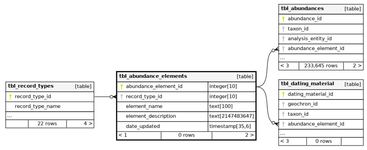
| abundance_element_id | element_name |
|---|---|
| 2 | Pollen grain |
| 3 | Leaf |
| 4 | Seed grain |
| 12 | Flower |
| 13 | Leaf bud |
| 18 | Needle |
| 19 | Cone |
| 20 | Flower bud |
| 21 | Flower |
| 22 | Leaf sheath |
| 23 | Culm node (solid) |
| 24 | Culm node (hollow) |
| 25 | Culm node (undefined) |
| 26 | Ear |
| 27 | Spikelet |
| 28 | Chaff |
| 29 | Awn fragment |
| 30 | Spikelet fork |
| 31 | Rachis fragment |
| 32 | Glume base |
| 33 | Rachis segment(S) |
| 34 | Palea |
| 35 | Lemma |
| 36 | Glume |
| 37 | Whole plant |
| 39 | Shell |
| 40 | Berry |
| 41 | Stem |
| 42 | Twig |
| 43 | Bark |
| 44 | Wood |
| 45 | Root |
| 46 | Corm (Root bulb/root tuber) |
| 47 | Cone scale |
| 48 | Endosperm |
| 49 | Straw |
3:
Central repository for storing bibliographic references in the SEAD database. It stores detailed citations, including author, title, year, publisher, and DOI/URL for various sources such as books and articles. This table connects to domain-specific tables via foreign keys, ensuring data integrity and supporting research by centralizing bibliographic information.
Contains information about materials used for dating processes. Materials can be linked to a specific taxon, pseudotaxon, or described in the ‘material_dated’ field. Specific components of abundance, such as seeds or elytrons, can also be indicated. A single dating instance may involve multiple materials.
Contains references for geochronological (radiometric) dating of samples.
Represents analysis entities, which are virtual constructs allowing the association of multiple proxies with a single physical sample. This enables the linking of physical samples to various measurements or counts across different methods. Analysis Entities are organized by datasets, which are constructed based on proxy requirements. Refer to the 'Dataset' documentation for more details.
Organizes collections of analysis entities into datasets, which are structured collections relevant to the specific proxy being studied. For biological proxies, a dataset typically corresponds to a spreadsheet containing samples and taxa for a single analysis method, such as phosphates through citric acid extraction.
- This needs connecting to the metadata tables, figure out which are child and which parent
Records information about physical samples collected from specific sites. Each sample is characterized by its location within the site, its physical properties measured in specific units (e.g., liters, kilograms), and its context within a sample set. Additionally, samples may have descriptive information, notes, and external identifiers linked to other systems.
Records the relative dating information for samples by associating a relative age definition with a physical sample through an analysis entity. It includes details about dating methods, notes, and indications of uncertainty (e.g., ‘from’, ‘ca’, ’<’).
Contains information about the physical dimensions of samples used for analysis, including both analyzed samples and non-analyzed residues.
Records tephrachronology-based sample dates, including associated uncertainties and additional notes.
Represents a virtual entity that defines a single proxy within a specific physical sample, acting as a statistical sample. A physical sample can contain multiple analysis entities, each linking various proxies. This structure facilitates the precise recording of specific species used in methods like radiocarbon dating.
Represents a collection of dated samples grouped for specific purposes, such as assigning a unified age range to samples in a master dataset or developing an age-depth model for a lake. These chronologies may also be used to integrate with external services that limit the scope of dating evidence, such as GBIF or SBDI.
Contains identifiers and names of radiocarbon laboratories sourced from radiocarbon.org/laboratories. Ensures transparency and traceability in radiocarbon and other radiometric dating records.
Represents analysis entities, which are virtual constructs allowing the association of multiple proxies with a single physical sample. This enables the linking of physical samples to various measurements or counts across different methods. Analysis Entities are organized by datasets, which are constructed based on proxy requirements. Refer to the 'Dataset' documentation for more details.
Defines various types of dating uncertainties, such as ‘from’, ‘to’, ‘circa (Ca.)’, and ’?’. These uncertainties help specify date ranges or approximate periods, such as ‘from Mesolithic to Neolithic’ or ‘from AD 100 to AD 300’.
| dating_uncertainty_id | description |
|---|---|
| 1 | Indication that the date is approximate, with unspecified or unquantifiable errors.Ca. |
| 2 | (For radiometric dates only). Oldest possible age of sample, often representing open ended dating where only one extreme limit is known. Occasionally used as part of a >< pair to define approximate age range. |
| 3 | (For radiometric dates only). Youngest possible age of sample, often representing open ended dating where only one extreme limit is known. Occasionally used as part of a >< pair to define approximate age range. |
| 4 | Oldest possible age of sample, usually part of a from-to pair, but could be used to represent open ended dating. |
| 5 | Youngest possible age of sample, usually part of a from-to pair, but could be used to represent open ended dating. |
| 6 | Approximate oldest possible age of sample, usually part of a from-to pair, but could be used to represent open ended dating. |
| 7 | Approximate youngest possible age of sample, usually part of a from-to pair, but could be used to represent open ended dating. |
| 8 | Dating is disputable. |
Contains radiometric dating information for samples, primarily radiocarbon, but also includes other methods such as Uranium series. These are also referred to as absolute dates.
Represents a major grouping identifier for datasets, typically indicating a contributing database, project, user, or laboratory (e.g., BugsCEP, MAL, Lund Dendro Lab).
Specifies the types of quantification methods used in datasets, including definitions of each classification system.
The below list of data types is sorted by groups, as defined by the data_type_group_id
Continuous data types
| data_type_id | data_type_name | definition | |
|---|---|---|---|
| 8 | Continuous | A measured quantity. | |
| 46 | Mixed-method dependent | Multiple datatypes from one method. (e.g. multiple isotope types from masspectrometry) |
Discrete data types
| data_type_id | data_type_name | definition | |
|---|---|---|---|
| 5 | Abundance | The absolute number of the counted element (e.g. seeds fossils) present in the sample. | |
| 9 | MNI | Minimum Number of Individual organisms as calculated from recorded parts (e.g. whole insect equivalents) |
Classification data types
| data_type_id | data_type_name | definition | |
|---|---|---|---|
| 19 | Categorical | Data classified according to a set of predefined categories (e.g. temperature classes |
Presence only
| data_type_id | data_type_name | definition | |
|---|---|---|---|
| 6 | Presence | The element/fossil is present in the sample but not quantified (numerical classification where 1 = presence) |
Relative scale data types
| data_type_id | data_type_name | definition | |
|---|---|---|---|
| 7 | Spot test interpretation | The relative intensity of a spot test result on a three grade scale: 12 3 where 3 is the highest. | |
| 20 | Percentage | Data expressed as a percentage (i.e. out x of 100) |
Composite scale data types
| data_type_id | data_type_name | definition | |
|---|---|---|---|
| 10 | Partial abundance | A legacy data type used in BugsCEP to represent partially quantified and incomplete lists e.g. quantified up to 50 individuals and then estimated. | |
| 13 | Undefined other | Data type is not clearly defined could be a combination of quantification presence/absence and semi-quantification or qualification. Beware of using data of this type for quantification. | |
| 18 | Categorical & Scaled (0-5 | Mix of data specified on a scale of 0 to 5 where 0 is absence and 5 is maximum amount of property and data classified on the presence of a property (e.g. Granite = tempering by granite present) |
Chronological data types
| data_type_id | data_type_name | definition | |
|---|---|---|---|
| 14 | Uncalibrated dates | Sample ages in uncalibrated values consisting of mean and error (+/-). Requires calibration to compare with calendar years. | |
| 15 | Counted dates | Sample ages derived from counted rings layers or dated events. | |
| 16 | Calendar dates | sample ages calibrated to calendar dates |
Geographical data types
| data_type_id | data_type_name | definition | |
|---|---|---|---|
| 43 | Estimated Years | Dates that are an estimation | |
| 44 | Composite date | A date which may include other information than the age such as season terminus and/or error margin. | |
| 45 | Approximate location | Geographical location given as approximate values or text. May include multiple levels text strings and exclusions (e.g. not Poland). |
Defines the categories of projects based on their primary purpose or objective, such as teaching, consultancy, research, or their combinations.
Organizes collections of analysis entities into datasets, which are structured collections relevant to the specific proxy being studied. For biological proxies, a dataset typically corresponds to a spreadsheet containing samples and taxa for a single analysis method, such as phosphates through citric acid extraction.
- This needs connecting to the metadata tables, figure out which are child and which parent
Defines the various stages of an investigation, such as desktop study, prospection, full excavation, and reanalysis.
Contains information about projects, including their names and descriptions, pertinent to datasets for specific sites.
Central repository for storing bibliographic references in the SEAD database. It stores detailed citations, including author, title, year, publisher, and DOI/URL for various sources such as books and articles. This table connects to domain-specific tables via foreign keys, ensuring data integrity and supporting research by centralizing bibliographic information.
Contains definitions and details of various analysis methods.
The full list of methods
(Sorted by tbl_method_groups, as of 2026-04-20, copied from https://browser.sead.se/postgrest/tbl\_methods)
1. Palaeobiological
| method_id | method_name | description | method_abbrev_or_alt_name |
|---|---|---|---|
| 3 | Palaeoentomology | Primarily fossil insect analyses, although other similar groups are usually included.\nThe method is commonly used for the reconstruction of natural and human environments in archaeological and palaeoecological contexts as well as climate change studies through the Mutual Climatic Range (MCR) method. \nStandard method: \n- samples disaggregated in warm water over a 300µm sieve; \n- excess water removed from sieved residue, then residue mixed with small amount of liquid paraffin (kerosene); \n- cold water added and left to stand for 15 minutes after which the floating (paraffin captured) fraction is pored into a 300µm sieve; \n- latter stage (fill, float, pour) repeated three times; paraffin washed out with detergent and warm water; \n- float is then stored and examined under a binocular microscope usually under 96% alcohol;\n- insect remains and other interesting finds are picked out and identified through the use of reference collections and identification keys.\nNOTE: storage in alcohol most likely has a detrimental effect on the possibility for using insect remains for C14 dating! Any samples where insect remains are to be dated should therefore be only stored in distilled water. | Fossil insects |
| 6 | Chironomid analyses | Non-biting midge (Chironomid) analyses, most commonly performed on lake sediments. | Chirono |
| 8 | Plant macrofossil analyses | The analysis of macro- or microscopic plant remains from either archaeological (archaeobotany) or ‘natural’ contexts.\nStandard method and variations:\n- samples are disaggregated in warm water and washed through a sieve (mesh size varies with application, most commonly 250 or 500µm);\n- material caught in the sieve is then either dried or stored in water/alcohol before sorting under a binocular microscope;\n- specimens are identified with the help of reference collections and identification keys. | Plant macros |
| 14 | Palynology | Pollen analysis. | Pollen |
| 15 | Charcoal analysis | The analysis of burnt/carbonised particles or fragments. | Charcoal |
| 40 | Mollusc analyses | Analysis of either land, fresh water or marine molluscs. | Molluscs |
| 111 | Plant macros (volume) | Plant macrofossil amount quantified by absolute volume | null |
| 175 | Ancient DNA analysis (Sample Extraction/Analysis) | Extraction and analysis of ancient DNA recovered from biological material (human, animal, plants, etc.) | aDNA-Sample |
| 176 | Ancient DNA analysis (Library Preparation) | Library preparation of ancient DNA recovered from biological material (human, animal, plants, etc.) | aDNA-Library |
2. Palaeo chemical/physical
| method_id | method_name | description | method_abbrev_or_alt_name | |
|---|---|---|---|---|
| 32 | Loss on ignition | An evaluation of the proportion of organic matter present in a sample, measured by comparing pre-burnt and post-burnt sample weights.\nStandard method: | LOI | |
| 33 | Magnetic susceptibility | A measurement of the ability of a sample to retain an induced magnetic field. | MS | |
| 35 | Magnetic susceptibility (Low frequency) | A measurement of the ability of a sample to retain a low frequency induced magnetic field. | MS-lo | |
| 36 | Magnetic susceptibility (High frequency) | A measurement of the ability of a sample to retain a high frequency induced magnetic field. | MS-hi | |
| 37 | Phosphate degrees | Amount of phosphates. Standard method: Inorganic phosphate content. Extraction by citric acid (2%). Based on Arrhenius and further developed by EAL. The amount of phosphate is specified as mg P2O5/100g dry soil. | P° | |
| 74 | Total phosphates citric acid | Measurement of total phosphate content through citric acid extraction and photospectrometer | citPtot | |
| 94 | Phosphate degrees HCL | Amount of phosphates. Standard method using HCL instead of citric acid. | P°HCL | |
| 106 | MS loop | Bartington MS2 & MS2D | null | |
| 107 | Conductivity µS (H2O) | Conductivity in µS (H2O) | null | |
| 109 | pH (H2O) | Acidity (pH) | null | 2 |
| 110 | pH (KCl 0,1M) | Acidity (pH) (KCl 0,1M) | null | |
| 118 | 0,6mm (%) | 0,6mm. Extracted through sieving. | Grain size 0,6-2mm (%) | |
| 119 | 0,6mm (%) | 0,6mm. Extracted through sieving. | 0,6 mm (%) |
3. Dating by radiometric methods
| method_id | method_name | description | method_abbrev_or_alt_name |
|---|---|---|---|
| 38 | C14 Accelerator dating | Accelerator Mass Spectrometer Carbon-14 dating. | C14 AMS |
| 39 | C14 Conventional | Conventional Carbon-14 dating. | C14 |
| 146 | U-Series U234/U238 | U234/U238 | |
| 147 | Uranium-Series (general) | U-Series | |
| 148 | Radiocarbon (14C Unspecified) | Dating by a radiocarbon method, the details of which are not provided in the publication or supporting material. | C14 Unspec. |
| 149 | Radiometric date by unknown method | Dating by an unspecified radiometric method (information missing in publication). | UnknownRadio |
| 151 | C14 Conventional | Conventional Carbon-14 dating. Uncalibrated dates. | C14 Std |
| 152 | Amino Acid Racemization | Age determination based on the post-mortem decay (or racemization/epimerization) of amino acids in fossils. The method has primarily been used to date shells, and less sucessfully on bone, teeth and wood under some conditions. | AAR |
| 153 | C14 dating of humic substances in sediment | Age determination by radiocarbon on humic substances extracted by pretreatment of sediments (e.g. peat, colluvium). A number of method variations are applied, aimed at dating different fractions of the sample (as opposed to the bulk dating of organic matter), including: humic acid fraction (alkali soluble) and humin fraction (alkali insoluble). Modern dates are generally determined through AMS, but older dates may have been aquired through standard counting. | C14 Humous |
| 154 | Argon39-Argon40 | Argon39-Argon 40 radiometric dating | Ar39-Ar40 |
| 159 | Interpolated C14 | Dating using the interpolation of 14C dates from other samples (give details in dating notes) | Interp 14C |
| 161 | Helium-Uranium | Dating based on the production of helium during the radioactive decay of uranium and thorium. | He-U |
| 162 | Chlorine 36 | Dating based on the radioactive decay of chlorine 36 | Cl36 |
| 163 | Uranium trend | Dating utilizing disequilibrium in the decay of Uranium-238, Uranium-234 and Thorium 230. | U-Trend |
| 164 | Berylium 10 | Dating based on the radioactive decay of berylium 10. | Be10 |
| 165 | Potassium-Argon | Dating based on the radioactive decay of potassium into argon. | K-Ar |
| 167 | U-Series Pa231/U235 | Dating based on the radioactive decay of uranium-series isotopes protactinium-231 and uranium-235. | Pa231/U235 |
| 168 | Lead 210 | Dating based on the measurement of radioactive isotope lead-210, which is a product of uranium decay. | Pb210 |
| 169 | U-Series Th230/U234 | Dating based on the radioactive decay of uranium-234 to thorium-230, and the degree to which secular equilibrium has been restored between these | Th230/U234 |
| 170 | Fission-Track | Dating based on the trails left in some glassy minerals as a result of the radioactive decay of uranium. | Fis-Track |
4. Modern biological
| method_id | method_name | description | method_abbrev_or_alt_name |
|---|---|---|---|
| 16 | Vegetation survey | Survey of modern (living) vegetation | Veg survey |
9. Biological/Chemical/Physical
| method_id | method_name | description | method_abbrev_or_alt_name |
|---|---|---|---|
| 21 | Non-pollen palynomorphs | Specimens commonly found in association with pollen analyses, and/or incorporated into pollen diagrams. | NPP |
| 117 | 2mm (%) | 2mm. Extracted through sieving. | 2mm (%) |
| 171 | Petrographic microscopy | A piece of the ceramic sherd is cut off, fastened to a microscope slide, ground down to 0,03 mm, and polished. The tempering grains and clay is then studied under a microscope to determine clay content, fraction size, sorting and tempering content. These are all determined ocularly. The max grain size and total percent tempering is determined by marking the tempering grains in a photograph projected from the camera connected to the microscope and calculating in the program. | Petrographic |
| 172 | Thermal analysis | A raw clay sample and a sample of the ceramic sherd, or archaeological sample, is heated in a lab oven in 100 °C intervals, for a total of 30 minutes, up to 1000 °C. The colour change during and after heating is noted and compared to the Munsell Colour Chart to determine the firing temperature and firing atmosphere of the archaeological sample. The samples are then once more heated above 1000 °C, in 50 °C intervals, until they reach their melting point. The assumption for the thermal analysis is that the colour change of the ceramic sample doesn’t occur until after the original firing temperature has been reached. | Thermal |
13. Sampling
| method_id | method_name | description | method_abbrev_or_alt_name |
|---|---|---|---|
| 53 | Core by Russian | Core taken using a Russian Auger | Russian core |
| 56 | Core by freeze corer | Core taken using a freeze corer | Freeze core |
| 57 | Kubiena sample | Samples taken using kubiena boxes | Kubiena |
| 58 | Monolith | Monolith samples from exposed section or excavated pit | Monolith |
| 60 | Grab samples | Samples taken in unspecified, non-rigourous method (e.g. excavator, spade, hands etc.) | Grab samples |
| 61 | Temporary record | Temporary record used for testing data entry where a field is manditory but no data exists as yet… | Temp record |
| 81 | Soil auger or probe | Soil extraction by auger or probe | Auger sample |
| 91 | Dendrochronology Cross-section | A cross section perpendicular to the grain is cut with a saw. | Dendro cross-section |
| 92 | Dendrochronology coring | Dendrochronological information extracted from a piece of wood by coring. | Dendro coring |
| 173 | Ceramics collection | Collection of ceramic samples by unspecified means | Ceramics |
14. Size measurement
| method_id | method_name | description | method_abbrev_or_alt_name |
|---|---|---|---|
| 46 | Volume estimate | Subjective estimation of (sample) volume - usually from bag size or bucket | Volume est. |
| 47 | Distance etc measurement | Distance measures: Height, length, depth or width measured by device | Length measured |
| 48 | Distance etc estimate | Distance measures: Height, length, depth or width estimated | Length est. |
| 51 | Volume measurement | Volume measured accuarately | Volume measured |
15. Colour
| method_id | method_name | description | method_abbrev_or_alt_name |
|---|---|---|---|
| 42 | Munsell Colour\n | Soil colour based on Munsell system.\n | Munsell |
| 44 | Subjective colour (trained) | Subjective colour description by a person qualified in sediment description, or with other experience of judging colour (e.g. artist, paint mixer).\n | Colour trained |
| 45 | Subjective colour (amateur) | Subjective colour description by untrained individual.\n | Colour untrained |
16. Preparation method
| method_id | method_name | description | method_abbrev_or_alt_name |
|---|---|---|---|
| 62 | Paraffin floatation | Reduction of sediment by floatation using paraffin (=kerosine, lysfotogen…). Commonly used for extracting insect remains, especially Coleaoptera… | Paraffin float |
| 65 | Hydroflouric acid treatment | Treatment with hydroflouric acid, generally to remove mineral (silicate) particles from pollen samples prior to slide preparation. | HF-treatment |
| 66 | Centrifugation | High velocity rotation of sample to separate contents by density. | Centrifuge |
| 82 | Heating at 550°C | Sample is heated in an over at 550°C. Generally used to burn off organic matter. | Heating 550 |
| 83 | Water floatation | Reduction of sediment by water floatation. Sample is washed through a seive to remove fine material and retrieve lighter organic matter. | Water floatation |
| 84 | Sieving >300µ retained | Separation through 300 micron sieve. Large fraction saved. | Sieving 300µ |
| 85 | Sieving >250µ retained | Separation through 250 micron sieve. Large fraction saved. | Sieving 250µ |
| 86 | Sieving >500µ retained | Separation through 500 micron sieve. Large fraction retained. | Sieving 500µ |
| 87 | Sieving >2mm retained | Separation through 2 mm sieve. Large fraction saved. | Sieving 2mm |
| 88 | Weak hydroxide solution added | Sample mixed with dilute hydroxide solution to spead up dissaggregation of sample. | Weak OH solution |
| 112 | Sieving 600µ | Preparation method: Sieving through 600µ seive (retaining seive contents) | null |
| 124 | Sieving 1.25mm | Preparation method: Sieving through 1.25mm seive (retaining seive contents) | null |
17. Coordinate and altitude systems
| method_id | method_name | description | method_abbrev_or_alt_name |
|---|---|---|---|
| 67 | UK Ordnance Survey National Grid | The United Kingdom National Grid system, established by the Ordnance Survey under the name OSGB36. | OSGB36 |
| 68 | Irish Grid Reference System | The Irish National Grid System, established by the Ordnance Survey of Ireland. | Irish National Grid |
| 69 | Swedish RT90[2.5 gon V] | Swedish Rikets Nät (National Grid) system. Full name “RT 90 2.5 gon V 0:-15”. X = south-north, Y = west-east. Essentially superceded by SWEREF 99 although still in extensive use.\nSee http://www.lantmateriet.se/templates/LMV\_Page.aspx?id=4766\&lang=EN (NOTE: include URL as biblio link) | RT90[2.5 gon V] |
| 70 | SWEREF 99 TM (Swedish) | Swedish geodetic reference system, based on UTM zone 33N bit extended to include the whole of Sweden.\nCoordinates are generally with decimeters of WGS 84 coordinates for the same place.\nSee http://www.lantmateriet.se/templates/LMV\_Page.aspx?id=4219 | SWEREF 99 TM |
| 71 | SWEREF 99 dd mm | Swedish geodetic reference system for local coordinates (where dd mm are replaced by the appropriate zone meridian.\nNOTE: exactly how we handle the specific zones yet to be discussed - maybe one method entry per zone? | SWEREF 99 dd mm |
| 72 | WGS84 | World Geodetic System.\nSystem is used by the Global Positioning System. | WGS84 |
| 73 | Local project grid | Any coordinate or grid system established for local recording of objects. Includes abstract archaeological site grids with origin (0,0) at any location.\nI available, conversion factors for alignment wiwth standard reference systesm should be given in site notes. | Local grid |
| 76 | Altitude above sea level | Height above sea level. Negative values are under standard sea level. | Alt |
| 77 | Depth from reference level | Depth from reference level. Negative values are above reference level. | Depth from datum |
| 78 | Height from datum | Height from reference level/datum. Negative values are below datum. | Height from datum |
| 79 | Depth from surface | Depth from ground or lake/river surface. Neqative values are above ground. Note: use altitude for relative to standard sea level. | Depth from surface |
| 80 | Height from surface | Height from ground or lake/river surface. Negative values below surface. Note: for heights above standard sea level use altitude. | Height from surface |
| 102 | Rikets höjdsystem 1970 | Rikets höjdsystem 1970. Swedish national altitude system 1970. | null |
| 103 | RT90 5 gon V | Rikets koordinatsystem RT90 5 gon V | null |
| 105 | Local or unknown grid | Site-specific grid or unknown site or sampling grid or coordinate system. | null |
| 108 | Göteborgs kommuns koordinatsystem | Göteborgs kommuns koordinatsystem. Gothenburg municipality coordinate system. | null |
| 113 | Malmö stads koordinatnät | Malmö stads koordinatnät. Malmä city coordinate system. In use until 2008-01-01 | null |
| 114 | WGS84 UTM zone 32 | Global coordinate system zone UTM 32 in WGS84 system. Last Revised: June 2, 1995 Area: World - N hemisphere - 6°E to 12°E - by country | null |
| 115 | Depth from surface lower sample boundary | Depth from surface lower sample boundary (depth is positive) | null |
| 116 | Depth surface to upper sample boundary | Depth from ground surface to upper sample boundary (depth is positive) | null |
| 120 | WGS84 UTM zone 33N | WGS84 UTM zone 33N | null |
| 121 | Rikets höjdsystem 1900 | \nKorrektioner: Ingen landhöjnings- eller tidjordskorrektion | RH 00 |
| 122 | Depth surface to lower sample boundary | Depth from ground surface to lower sample boundary (depth is positive) | null |
| 123 | EUREF89 UTM U32 | Official geodetic datum (reference system/projection) of Norway. UTM zone U32. EUREF89. https://www.kartverket.no/Posisjonstjenester/Kartprojeksjoner/ | null |
| 125 | Upper sample boundary (positive depth) | Upper sample boundary positive | null |
| 126 | Lower sample boundary (positive depth) | Lower sample boundary depth positive | null |
18. Soil horizon
| method_id | method_name | description | method_abbrev_or_alt_name |
|---|---|---|---|
| 97 | ISRIC soil horizons | Soil horizon classification according to strict International Soil Reference and Information Center (ISRIC) guidelines. http://www.isric.org/isric/webdocs/docs/ISRIC\_TechPap19.pdf | ISRIC horizons |
| 98 | FAO soil horizons | Soil horizon classification according to strict Food and Argriculture Organization of the United Nations (FAO) guidelines. ftp://ftp.fao.org/agl/agll/docs/guidel_soil_descr.pdf and http://www.fao.org/docrep/W8594E/w8594e0g.htm for more detailed descriptions. | FAO horizons |
| 100 | Goldberg & Macphail soil horizons | Soil horizon calssification according to Goldberg & Macphail (2006) Practical and theoretical geoarchaeology. Variation and simplification of ISRIC system. | Goldberg & Macphail horizons |
| 101 | Soil horizons by undefined system | Soil horizons given without any specified classification system. | Undefined system horizons |
| 104 | MAL soil horizon classifications | Qualitative soil horizon classifications used by MAL. Derived from: Troedsson, Tryggve & Nykvist, Nils (1973). Marklära och markvård. Stockholm: Almqvist & Wiksell | null |
19. Dating to period
| method_id | method_name | description | method_abbrev_or_alt_name |
|---|---|---|---|
| 127 | Pollen Zonation | Age determined by comparison of pollen flora with reference data. A number of standard regional pollen zones have been determined through the compilation and zonation of multiple pollen profiles. Zonation is general achieved through the identification of significant changes in fauna (e.g. from birch to pine dominated), either manually or through cluster analysis. | PollenZone |
| 128 | Archaeological period calendar years | Age determined by comparison of pollen flora with reference data. A number of standard regional pollen zones have been determined through the compilation and zonation of multiple pollen profiles. Zonation is general achieved through the identification of significant changes in fauna (e.g. from birch to pine dominated), either manually or through cluster analysis. | ArchPerCal |
| 129 | Archaeological period C14 years | Age determined to an archaeological period defined in 14C years. This is a bulk method for numerous techniques for assigning a deposit to a particular cultural period, where the period boundaries have been defined by radiocarbon dating. More specific method details should preferably be given as to how the date has been derived, but may not be available. | ArchPerC14 |
| 130 | Historical Period | Age determined to historical period. More specific method details should preferably be given as to how the date has been derived, but may not be available. | HistPer |
| 131 | Geological calendar period | Age determined to geological period defined in calendar years. More specific method details should preferably be given as to how the date has been derived, but may not be available. | GeolPerCal |
| 132 | Geological C14 period | Age determined to geological period defined in C14 years. More specific method details should preferably be given as to how the date has been derived, but may not be available. | GeolPerC14 |
| 133 | Geological radiometric period | Age determined to geological period defined by radiometric methods but not necessarily radiocarbon (e.g. U-series). More specific method details should preferably be given as to how the date has been derived, but may not be available. | GeolPerRadio |
| 134 | Stratigraphic (Geological) | Dating through strategraphic association, placing the sediment (and enclosed artefacts) in the context of geological layers of known or unknown age. | Strat(Geol) |
| 137 | Artefact typology (calendar years) | Dating by artefact typology with calendar date. The form, design and material of an artefact may allow it to be placed in the context of a known sequence of artefact characteristics (a typological sequence). This allows it to be dated through the assumption that the typologies are correctly and independently dated. There is a slight danger or circular reasoning is the constraints of independent dating are not rigourously enforced, and a tendency for typologies to persist even if evidence suggests that there may be problems. | TypoCal |
| 138 | Artefact typology (radiometric years) | Dating by artefact typology with radiometric date. The form, design and material of an artefact may allow it to be placed in the context of a known sequence of artefact characteristics (a typological sequence). This allows it to be dated through the assumption that the typologies are correctly and independently dated. There is a slight danger or circular reasoning is the constraints of independent dating are not rigourously enforced, and a tendency for typologies to persist even if evidence suggests that there may be problems. | TypoRadio |
| 158 | Geological period (unspecified years) | Age determined to geological period using undefined (or possibly multiple) method(s). | GeolPer |
20. Dating to calendar year(s)
| method_id | method_name | description | method_abbrev_or_alt_name |
|---|---|---|---|
| 10 | Dendrochronology | Dating by comparison of tree-ring sequences. | Dendro |
| 135 | Tephrochronology Calendar | Dating by relation to volcanic ash layer of a known calendar age. | TephraCal |
| 136 | Tephrochronology C14 | Dating by relation to volcanic ash layer dated by radiocarbon. | TephraC14 |
| 139 | Other archaeological dating | Unspecified dating method leading to an archaeological date in calendar years. | ArchCal |
| 140 | Wiggle matching of 14C dates | A sequence of radiocarbon dates may be compared with variation in the C14 calibration curve, and dates nudged so that they align with the curve. The method requires a sequence to be tightly dated and may be especially useful around flatter parts of the calibration curve. User discretion is required. | Wiggle |
| 141 | Lichenometry | Dating method which relies on the predictable growth pattern of some lichen species. Some lichens (e.g. Rhizocarpon geographicum) exhibit colonisation, linear growth and non-linear phases of growth. By calibrating sizes against surfaces of known age (e.g. buildings, grave stones) it is possible to guage the age of exposure of a surface through the sizes of the lichens growing on it. A number of variations exist in terms of how to measure. The method has been applied to historical and archaeological remains as well as to geological features such as erosion surfaces and raised beaches. | Lichen |
| 142 | Calendar date by unknown method | Calendar years derived by unknown or unspecified method. | UnknownCal |
| 143 | Geologically derived calendar date | Derivation of calendar date by reference to geological processes, features or events (e.g. volcanic eruption, earthquake). | GeolCal |
| 144 | Historical Records | Dating based on historical documentation. | HistCal |
| 155 | Archaeological period (unspecified) | Period based dating method leading to a range of potential archaeological dates in unspecified years. | ArchPer |
| 156 | Calibrated radiocarbon date (method unspecified) | Calendar years date provided by the calibration of a radiocarbon age. Exact dating method unspecified. | Cal |
| 157 | Calibrated AMS radiocarbon date | Calendar years date provided by calibration of an AMS radiocarbon age. | CalAMS |
21. Dating by other method
| method_id | method_name | description | method_abbrev_or_alt_name |
|---|---|---|---|
| 145 | Other date by unknown method | Unspecified dating method. | UnknownOther |
| 160 | Electron Spin Resonance | Dating based on the trapped charges of electrons, electron spin resonance dating. | ESR |
| 166 | Orbital Tuning | Dating through the synchronization of events according to Milankovitch cycles, casused by changes in the Earth’s orbit, and their expected effects on climate. | Orb-Tuning |
| 174 | Composite chronology | Chronology derived from a combination of dates using various methods. | Composite chronology |
22. Dating by radi+ation exposure methods
| method_id | method_name | description | method_abbrev_or_alt_name | |
|---|---|---|---|---|
| 150 | Thermoluminescence | Dating using the release of stored energy properties of (mainly sonte) material previously exposed to the sun. | TL | 22 |
Contains information about projects, including their names and descriptions, pertinent to datasets for specific sites.
Organizes collections of analysis entities into datasets, which are structured collections relevant to the specific proxy being studied. For biological proxies, a dataset typically corresponds to a spreadsheet containing samples and taxa for a single analysis method, such as phosphates through citric acid extraction.
- This needs connecting to the metadata tables, figure out which are child and which parent
Represents analysis entities, which are virtual constructs allowing the association of multiple proxies with a single physical sample. This enables the linking of physical samples to various measurements or counts across different methods. Analysis Entities are organized by datasets, which are constructed based on proxy requirements. Refer to the 'Dataset' documentation for more details.
Contains information about one or more contacts related to a dataset, such as data providers or digitalisers.
Contains records of various submission events related to a dataset, such as initial recording, database entries, and integrations with SEAD.
this table will be depreciated
Roger let me know in October of 2026 that this table will be depreciated in favour of tbl_data_providers
Contains definitions and details of various analysis methods.
The full list of methods
(Sorted by tbl_method_groups, as of 2026-04-20, copied from https://browser.sead.se/postgrest/tbl\_methods)
1. Palaeobiological
| method_id | method_name | description | method_abbrev_or_alt_name |
|---|---|---|---|
| 3 | Palaeoentomology | Primarily fossil insect analyses, although other similar groups are usually included.\nThe method is commonly used for the reconstruction of natural and human environments in archaeological and palaeoecological contexts as well as climate change studies through the Mutual Climatic Range (MCR) method. \nStandard method: \n- samples disaggregated in warm water over a 300µm sieve; \n- excess water removed from sieved residue, then residue mixed with small amount of liquid paraffin (kerosene); \n- cold water added and left to stand for 15 minutes after which the floating (paraffin captured) fraction is pored into a 300µm sieve; \n- latter stage (fill, float, pour) repeated three times; paraffin washed out with detergent and warm water; \n- float is then stored and examined under a binocular microscope usually under 96% alcohol;\n- insect remains and other interesting finds are picked out and identified through the use of reference collections and identification keys.\nNOTE: storage in alcohol most likely has a detrimental effect on the possibility for using insect remains for C14 dating! Any samples where insect remains are to be dated should therefore be only stored in distilled water. | Fossil insects |
| 6 | Chironomid analyses | Non-biting midge (Chironomid) analyses, most commonly performed on lake sediments. | Chirono |
| 8 | Plant macrofossil analyses | The analysis of macro- or microscopic plant remains from either archaeological (archaeobotany) or ‘natural’ contexts.\nStandard method and variations:\n- samples are disaggregated in warm water and washed through a sieve (mesh size varies with application, most commonly 250 or 500µm);\n- material caught in the sieve is then either dried or stored in water/alcohol before sorting under a binocular microscope;\n- specimens are identified with the help of reference collections and identification keys. | Plant macros |
| 14 | Palynology | Pollen analysis. | Pollen |
| 15 | Charcoal analysis | The analysis of burnt/carbonised particles or fragments. | Charcoal |
| 40 | Mollusc analyses | Analysis of either land, fresh water or marine molluscs. | Molluscs |
| 111 | Plant macros (volume) | Plant macrofossil amount quantified by absolute volume | null |
| 175 | Ancient DNA analysis (Sample Extraction/Analysis) | Extraction and analysis of ancient DNA recovered from biological material (human, animal, plants, etc.) | aDNA-Sample |
| 176 | Ancient DNA analysis (Library Preparation) | Library preparation of ancient DNA recovered from biological material (human, animal, plants, etc.) | aDNA-Library |
2. Palaeo chemical/physical
| method_id | method_name | description | method_abbrev_or_alt_name | |
|---|---|---|---|---|
| 32 | Loss on ignition | An evaluation of the proportion of organic matter present in a sample, measured by comparing pre-burnt and post-burnt sample weights.\nStandard method: | LOI | |
| 33 | Magnetic susceptibility | A measurement of the ability of a sample to retain an induced magnetic field. | MS | |
| 35 | Magnetic susceptibility (Low frequency) | A measurement of the ability of a sample to retain a low frequency induced magnetic field. | MS-lo | |
| 36 | Magnetic susceptibility (High frequency) | A measurement of the ability of a sample to retain a high frequency induced magnetic field. | MS-hi | |
| 37 | Phosphate degrees | Amount of phosphates. Standard method: Inorganic phosphate content. Extraction by citric acid (2%). Based on Arrhenius and further developed by EAL. The amount of phosphate is specified as mg P2O5/100g dry soil. | P° | |
| 74 | Total phosphates citric acid | Measurement of total phosphate content through citric acid extraction and photospectrometer | citPtot | |
| 94 | Phosphate degrees HCL | Amount of phosphates. Standard method using HCL instead of citric acid. | P°HCL | |
| 106 | MS loop | Bartington MS2 & MS2D | null | |
| 107 | Conductivity µS (H2O) | Conductivity in µS (H2O) | null | |
| 109 | pH (H2O) | Acidity (pH) | null | 2 |
| 110 | pH (KCl 0,1M) | Acidity (pH) (KCl 0,1M) | null | |
| 118 | 0,6mm (%) | 0,6mm. Extracted through sieving. | Grain size 0,6-2mm (%) | |
| 119 | 0,6mm (%) | 0,6mm. Extracted through sieving. | 0,6 mm (%) |
3. Dating by radiometric methods
| method_id | method_name | description | method_abbrev_or_alt_name |
|---|---|---|---|
| 38 | C14 Accelerator dating | Accelerator Mass Spectrometer Carbon-14 dating. | C14 AMS |
| 39 | C14 Conventional | Conventional Carbon-14 dating. | C14 |
| 146 | U-Series U234/U238 | U234/U238 | |
| 147 | Uranium-Series (general) | U-Series | |
| 148 | Radiocarbon (14C Unspecified) | Dating by a radiocarbon method, the details of which are not provided in the publication or supporting material. | C14 Unspec. |
| 149 | Radiometric date by unknown method | Dating by an unspecified radiometric method (information missing in publication). | UnknownRadio |
| 151 | C14 Conventional | Conventional Carbon-14 dating. Uncalibrated dates. | C14 Std |
| 152 | Amino Acid Racemization | Age determination based on the post-mortem decay (or racemization/epimerization) of amino acids in fossils. The method has primarily been used to date shells, and less sucessfully on bone, teeth and wood under some conditions. | AAR |
| 153 | C14 dating of humic substances in sediment | Age determination by radiocarbon on humic substances extracted by pretreatment of sediments (e.g. peat, colluvium). A number of method variations are applied, aimed at dating different fractions of the sample (as opposed to the bulk dating of organic matter), including: humic acid fraction (alkali soluble) and humin fraction (alkali insoluble). Modern dates are generally determined through AMS, but older dates may have been aquired through standard counting. | C14 Humous |
| 154 | Argon39-Argon40 | Argon39-Argon 40 radiometric dating | Ar39-Ar40 |
| 159 | Interpolated C14 | Dating using the interpolation of 14C dates from other samples (give details in dating notes) | Interp 14C |
| 161 | Helium-Uranium | Dating based on the production of helium during the radioactive decay of uranium and thorium. | He-U |
| 162 | Chlorine 36 | Dating based on the radioactive decay of chlorine 36 | Cl36 |
| 163 | Uranium trend | Dating utilizing disequilibrium in the decay of Uranium-238, Uranium-234 and Thorium 230. | U-Trend |
| 164 | Berylium 10 | Dating based on the radioactive decay of berylium 10. | Be10 |
| 165 | Potassium-Argon | Dating based on the radioactive decay of potassium into argon. | K-Ar |
| 167 | U-Series Pa231/U235 | Dating based on the radioactive decay of uranium-series isotopes protactinium-231 and uranium-235. | Pa231/U235 |
| 168 | Lead 210 | Dating based on the measurement of radioactive isotope lead-210, which is a product of uranium decay. | Pb210 |
| 169 | U-Series Th230/U234 | Dating based on the radioactive decay of uranium-234 to thorium-230, and the degree to which secular equilibrium has been restored between these | Th230/U234 |
| 170 | Fission-Track | Dating based on the trails left in some glassy minerals as a result of the radioactive decay of uranium. | Fis-Track |
4. Modern biological
| method_id | method_name | description | method_abbrev_or_alt_name |
|---|---|---|---|
| 16 | Vegetation survey | Survey of modern (living) vegetation | Veg survey |
9. Biological/Chemical/Physical
| method_id | method_name | description | method_abbrev_or_alt_name |
|---|---|---|---|
| 21 | Non-pollen palynomorphs | Specimens commonly found in association with pollen analyses, and/or incorporated into pollen diagrams. | NPP |
| 117 | 2mm (%) | 2mm. Extracted through sieving. | 2mm (%) |
| 171 | Petrographic microscopy | A piece of the ceramic sherd is cut off, fastened to a microscope slide, ground down to 0,03 mm, and polished. The tempering grains and clay is then studied under a microscope to determine clay content, fraction size, sorting and tempering content. These are all determined ocularly. The max grain size and total percent tempering is determined by marking the tempering grains in a photograph projected from the camera connected to the microscope and calculating in the program. | Petrographic |
| 172 | Thermal analysis | A raw clay sample and a sample of the ceramic sherd, or archaeological sample, is heated in a lab oven in 100 °C intervals, for a total of 30 minutes, up to 1000 °C. The colour change during and after heating is noted and compared to the Munsell Colour Chart to determine the firing temperature and firing atmosphere of the archaeological sample. The samples are then once more heated above 1000 °C, in 50 °C intervals, until they reach their melting point. The assumption for the thermal analysis is that the colour change of the ceramic sample doesn’t occur until after the original firing temperature has been reached. | Thermal |
13. Sampling
| method_id | method_name | description | method_abbrev_or_alt_name |
|---|---|---|---|
| 53 | Core by Russian | Core taken using a Russian Auger | Russian core |
| 56 | Core by freeze corer | Core taken using a freeze corer | Freeze core |
| 57 | Kubiena sample | Samples taken using kubiena boxes | Kubiena |
| 58 | Monolith | Monolith samples from exposed section or excavated pit | Monolith |
| 60 | Grab samples | Samples taken in unspecified, non-rigourous method (e.g. excavator, spade, hands etc.) | Grab samples |
| 61 | Temporary record | Temporary record used for testing data entry where a field is manditory but no data exists as yet… | Temp record |
| 81 | Soil auger or probe | Soil extraction by auger or probe | Auger sample |
| 91 | Dendrochronology Cross-section | A cross section perpendicular to the grain is cut with a saw. | Dendro cross-section |
| 92 | Dendrochronology coring | Dendrochronological information extracted from a piece of wood by coring. | Dendro coring |
| 173 | Ceramics collection | Collection of ceramic samples by unspecified means | Ceramics |
14. Size measurement
| method_id | method_name | description | method_abbrev_or_alt_name |
|---|---|---|---|
| 46 | Volume estimate | Subjective estimation of (sample) volume - usually from bag size or bucket | Volume est. |
| 47 | Distance etc measurement | Distance measures: Height, length, depth or width measured by device | Length measured |
| 48 | Distance etc estimate | Distance measures: Height, length, depth or width estimated | Length est. |
| 51 | Volume measurement | Volume measured accuarately | Volume measured |
15. Colour
| method_id | method_name | description | method_abbrev_or_alt_name |
|---|---|---|---|
| 42 | Munsell Colour\n | Soil colour based on Munsell system.\n | Munsell |
| 44 | Subjective colour (trained) | Subjective colour description by a person qualified in sediment description, or with other experience of judging colour (e.g. artist, paint mixer).\n | Colour trained |
| 45 | Subjective colour (amateur) | Subjective colour description by untrained individual.\n | Colour untrained |
16. Preparation method
| method_id | method_name | description | method_abbrev_or_alt_name |
|---|---|---|---|
| 62 | Paraffin floatation | Reduction of sediment by floatation using paraffin (=kerosine, lysfotogen…). Commonly used for extracting insect remains, especially Coleaoptera… | Paraffin float |
| 65 | Hydroflouric acid treatment | Treatment with hydroflouric acid, generally to remove mineral (silicate) particles from pollen samples prior to slide preparation. | HF-treatment |
| 66 | Centrifugation | High velocity rotation of sample to separate contents by density. | Centrifuge |
| 82 | Heating at 550°C | Sample is heated in an over at 550°C. Generally used to burn off organic matter. | Heating 550 |
| 83 | Water floatation | Reduction of sediment by water floatation. Sample is washed through a seive to remove fine material and retrieve lighter organic matter. | Water floatation |
| 84 | Sieving >300µ retained | Separation through 300 micron sieve. Large fraction saved. | Sieving 300µ |
| 85 | Sieving >250µ retained | Separation through 250 micron sieve. Large fraction saved. | Sieving 250µ |
| 86 | Sieving >500µ retained | Separation through 500 micron sieve. Large fraction retained. | Sieving 500µ |
| 87 | Sieving >2mm retained | Separation through 2 mm sieve. Large fraction saved. | Sieving 2mm |
| 88 | Weak hydroxide solution added | Sample mixed with dilute hydroxide solution to spead up dissaggregation of sample. | Weak OH solution |
| 112 | Sieving 600µ | Preparation method: Sieving through 600µ seive (retaining seive contents) | null |
| 124 | Sieving 1.25mm | Preparation method: Sieving through 1.25mm seive (retaining seive contents) | null |
17. Coordinate and altitude systems
| method_id | method_name | description | method_abbrev_or_alt_name |
|---|---|---|---|
| 67 | UK Ordnance Survey National Grid | The United Kingdom National Grid system, established by the Ordnance Survey under the name OSGB36. | OSGB36 |
| 68 | Irish Grid Reference System | The Irish National Grid System, established by the Ordnance Survey of Ireland. | Irish National Grid |
| 69 | Swedish RT90[2.5 gon V] | Swedish Rikets Nät (National Grid) system. Full name “RT 90 2.5 gon V 0:-15”. X = south-north, Y = west-east. Essentially superceded by SWEREF 99 although still in extensive use.\nSee http://www.lantmateriet.se/templates/LMV\_Page.aspx?id=4766\&lang=EN (NOTE: include URL as biblio link) | RT90[2.5 gon V] |
| 70 | SWEREF 99 TM (Swedish) | Swedish geodetic reference system, based on UTM zone 33N bit extended to include the whole of Sweden.\nCoordinates are generally with decimeters of WGS 84 coordinates for the same place.\nSee http://www.lantmateriet.se/templates/LMV\_Page.aspx?id=4219 | SWEREF 99 TM |
| 71 | SWEREF 99 dd mm | Swedish geodetic reference system for local coordinates (where dd mm are replaced by the appropriate zone meridian.\nNOTE: exactly how we handle the specific zones yet to be discussed - maybe one method entry per zone? | SWEREF 99 dd mm |
| 72 | WGS84 | World Geodetic System.\nSystem is used by the Global Positioning System. | WGS84 |
| 73 | Local project grid | Any coordinate or grid system established for local recording of objects. Includes abstract archaeological site grids with origin (0,0) at any location.\nI available, conversion factors for alignment wiwth standard reference systesm should be given in site notes. | Local grid |
| 76 | Altitude above sea level | Height above sea level. Negative values are under standard sea level. | Alt |
| 77 | Depth from reference level | Depth from reference level. Negative values are above reference level. | Depth from datum |
| 78 | Height from datum | Height from reference level/datum. Negative values are below datum. | Height from datum |
| 79 | Depth from surface | Depth from ground or lake/river surface. Neqative values are above ground. Note: use altitude for relative to standard sea level. | Depth from surface |
| 80 | Height from surface | Height from ground or lake/river surface. Negative values below surface. Note: for heights above standard sea level use altitude. | Height from surface |
| 102 | Rikets höjdsystem 1970 | Rikets höjdsystem 1970. Swedish national altitude system 1970. | null |
| 103 | RT90 5 gon V | Rikets koordinatsystem RT90 5 gon V | null |
| 105 | Local or unknown grid | Site-specific grid or unknown site or sampling grid or coordinate system. | null |
| 108 | Göteborgs kommuns koordinatsystem | Göteborgs kommuns koordinatsystem. Gothenburg municipality coordinate system. | null |
| 113 | Malmö stads koordinatnät | Malmö stads koordinatnät. Malmä city coordinate system. In use until 2008-01-01 | null |
| 114 | WGS84 UTM zone 32 | Global coordinate system zone UTM 32 in WGS84 system. Last Revised: June 2, 1995 Area: World - N hemisphere - 6°E to 12°E - by country | null |
| 115 | Depth from surface lower sample boundary | Depth from surface lower sample boundary (depth is positive) | null |
| 116 | Depth surface to upper sample boundary | Depth from ground surface to upper sample boundary (depth is positive) | null |
| 120 | WGS84 UTM zone 33N | WGS84 UTM zone 33N | null |
| 121 | Rikets höjdsystem 1900 | \nKorrektioner: Ingen landhöjnings- eller tidjordskorrektion | RH 00 |
| 122 | Depth surface to lower sample boundary | Depth from ground surface to lower sample boundary (depth is positive) | null |
| 123 | EUREF89 UTM U32 | Official geodetic datum (reference system/projection) of Norway. UTM zone U32. EUREF89. https://www.kartverket.no/Posisjonstjenester/Kartprojeksjoner/ | null |
| 125 | Upper sample boundary (positive depth) | Upper sample boundary positive | null |
| 126 | Lower sample boundary (positive depth) | Lower sample boundary depth positive | null |
18. Soil horizon
| method_id | method_name | description | method_abbrev_or_alt_name |
|---|---|---|---|
| 97 | ISRIC soil horizons | Soil horizon classification according to strict International Soil Reference and Information Center (ISRIC) guidelines. http://www.isric.org/isric/webdocs/docs/ISRIC\_TechPap19.pdf | ISRIC horizons |
| 98 | FAO soil horizons | Soil horizon classification according to strict Food and Argriculture Organization of the United Nations (FAO) guidelines. ftp://ftp.fao.org/agl/agll/docs/guidel_soil_descr.pdf and http://www.fao.org/docrep/W8594E/w8594e0g.htm for more detailed descriptions. | FAO horizons |
| 100 | Goldberg & Macphail soil horizons | Soil horizon calssification according to Goldberg & Macphail (2006) Practical and theoretical geoarchaeology. Variation and simplification of ISRIC system. | Goldberg & Macphail horizons |
| 101 | Soil horizons by undefined system | Soil horizons given without any specified classification system. | Undefined system horizons |
| 104 | MAL soil horizon classifications | Qualitative soil horizon classifications used by MAL. Derived from: Troedsson, Tryggve & Nykvist, Nils (1973). Marklära och markvård. Stockholm: Almqvist & Wiksell | null |
19. Dating to period
| method_id | method_name | description | method_abbrev_or_alt_name |
|---|---|---|---|
| 127 | Pollen Zonation | Age determined by comparison of pollen flora with reference data. A number of standard regional pollen zones have been determined through the compilation and zonation of multiple pollen profiles. Zonation is general achieved through the identification of significant changes in fauna (e.g. from birch to pine dominated), either manually or through cluster analysis. | PollenZone |
| 128 | Archaeological period calendar years | Age determined by comparison of pollen flora with reference data. A number of standard regional pollen zones have been determined through the compilation and zonation of multiple pollen profiles. Zonation is general achieved through the identification of significant changes in fauna (e.g. from birch to pine dominated), either manually or through cluster analysis. | ArchPerCal |
| 129 | Archaeological period C14 years | Age determined to an archaeological period defined in 14C years. This is a bulk method for numerous techniques for assigning a deposit to a particular cultural period, where the period boundaries have been defined by radiocarbon dating. More specific method details should preferably be given as to how the date has been derived, but may not be available. | ArchPerC14 |
| 130 | Historical Period | Age determined to historical period. More specific method details should preferably be given as to how the date has been derived, but may not be available. | HistPer |
| 131 | Geological calendar period | Age determined to geological period defined in calendar years. More specific method details should preferably be given as to how the date has been derived, but may not be available. | GeolPerCal |
| 132 | Geological C14 period | Age determined to geological period defined in C14 years. More specific method details should preferably be given as to how the date has been derived, but may not be available. | GeolPerC14 |
| 133 | Geological radiometric period | Age determined to geological period defined by radiometric methods but not necessarily radiocarbon (e.g. U-series). More specific method details should preferably be given as to how the date has been derived, but may not be available. | GeolPerRadio |
| 134 | Stratigraphic (Geological) | Dating through strategraphic association, placing the sediment (and enclosed artefacts) in the context of geological layers of known or unknown age. | Strat(Geol) |
| 137 | Artefact typology (calendar years) | Dating by artefact typology with calendar date. The form, design and material of an artefact may allow it to be placed in the context of a known sequence of artefact characteristics (a typological sequence). This allows it to be dated through the assumption that the typologies are correctly and independently dated. There is a slight danger or circular reasoning is the constraints of independent dating are not rigourously enforced, and a tendency for typologies to persist even if evidence suggests that there may be problems. | TypoCal |
| 138 | Artefact typology (radiometric years) | Dating by artefact typology with radiometric date. The form, design and material of an artefact may allow it to be placed in the context of a known sequence of artefact characteristics (a typological sequence). This allows it to be dated through the assumption that the typologies are correctly and independently dated. There is a slight danger or circular reasoning is the constraints of independent dating are not rigourously enforced, and a tendency for typologies to persist even if evidence suggests that there may be problems. | TypoRadio |
| 158 | Geological period (unspecified years) | Age determined to geological period using undefined (or possibly multiple) method(s). | GeolPer |
20. Dating to calendar year(s)
| method_id | method_name | description | method_abbrev_or_alt_name |
|---|---|---|---|
| 10 | Dendrochronology | Dating by comparison of tree-ring sequences. | Dendro |
| 135 | Tephrochronology Calendar | Dating by relation to volcanic ash layer of a known calendar age. | TephraCal |
| 136 | Tephrochronology C14 | Dating by relation to volcanic ash layer dated by radiocarbon. | TephraC14 |
| 139 | Other archaeological dating | Unspecified dating method leading to an archaeological date in calendar years. | ArchCal |
| 140 | Wiggle matching of 14C dates | A sequence of radiocarbon dates may be compared with variation in the C14 calibration curve, and dates nudged so that they align with the curve. The method requires a sequence to be tightly dated and may be especially useful around flatter parts of the calibration curve. User discretion is required. | Wiggle |
| 141 | Lichenometry | Dating method which relies on the predictable growth pattern of some lichen species. Some lichens (e.g. Rhizocarpon geographicum) exhibit colonisation, linear growth and non-linear phases of growth. By calibrating sizes against surfaces of known age (e.g. buildings, grave stones) it is possible to guage the age of exposure of a surface through the sizes of the lichens growing on it. A number of variations exist in terms of how to measure. The method has been applied to historical and archaeological remains as well as to geological features such as erosion surfaces and raised beaches. | Lichen |
| 142 | Calendar date by unknown method | Calendar years derived by unknown or unspecified method. | UnknownCal |
| 143 | Geologically derived calendar date | Derivation of calendar date by reference to geological processes, features or events (e.g. volcanic eruption, earthquake). | GeolCal |
| 144 | Historical Records | Dating based on historical documentation. | HistCal |
| 155 | Archaeological period (unspecified) | Period based dating method leading to a range of potential archaeological dates in unspecified years. | ArchPer |
| 156 | Calibrated radiocarbon date (method unspecified) | Calendar years date provided by the calibration of a radiocarbon age. Exact dating method unspecified. | Cal |
| 157 | Calibrated AMS radiocarbon date | Calendar years date provided by calibration of an AMS radiocarbon age. | CalAMS |
21. Dating by other method
| method_id | method_name | description | method_abbrev_or_alt_name |
|---|---|---|---|
| 145 | Other date by unknown method | Unspecified dating method. | UnknownOther |
| 160 | Electron Spin Resonance | Dating based on the trapped charges of electrons, electron spin resonance dating. | ESR |
| 166 | Orbital Tuning | Dating through the synchronization of events according to Milankovitch cycles, casused by changes in the Earth’s orbit, and their expected effects on climate. | Orb-Tuning |
| 174 | Composite chronology | Chronology derived from a combination of dates using various methods. | Composite chronology |
22. Dating by radi+ation exposure methods
| method_id | method_name | description | method_abbrev_or_alt_name | |
|---|---|---|---|---|
| 150 | Thermoluminescence | Dating using the release of stored energy properties of (mainly sonte) material previously exposed to the sun. | TL | 22 |
Represents analysis entities, which are virtual constructs allowing the association of multiple proxies with a single physical sample. This enables the linking of physical samples to various measurements or counts across different methods. Analysis Entities are organized by datasets, which are constructed based on proxy requirements. Refer to the 'Dataset' documentation for more details.
nan
Provides a reference for different chronological systems used to denote years, such as AD, BC, and BP.
Defines various types of dating uncertainties, such as ‘from’, ‘to’, ‘circa (Ca.)’, and ’?’. These uncertainties help specify date ranges or approximate periods, such as ‘from Mesolithic to Neolithic’ or ‘from AD 100 to AD 300’.
| dating_uncertainty_id | description |
|---|---|
| 1 | Indication that the date is approximate, with unspecified or unquantifiable errors.Ca. |
| 2 | (For radiometric dates only). Oldest possible age of sample, often representing open ended dating where only one extreme limit is known. Occasionally used as part of a >< pair to define approximate age range. |
| 3 | (For radiometric dates only). Youngest possible age of sample, often representing open ended dating where only one extreme limit is known. Occasionally used as part of a >< pair to define approximate age range. |
| 4 | Oldest possible age of sample, usually part of a from-to pair, but could be used to represent open ended dating. |
| 5 | Youngest possible age of sample, usually part of a from-to pair, but could be used to represent open ended dating. |
| 6 | Approximate oldest possible age of sample, usually part of a from-to pair, but could be used to represent open ended dating. |
| 7 | Approximate youngest possible age of sample, usually part of a from-to pair, but could be used to represent open ended dating. |
| 8 | Dating is disputable. |
type=lookup
20130722PIB: Added field dating_uncertainty_id to cater for >< etc. 20130722pib: prefixed fieldnames age_younger and age_older with “cal_” to conform with equivalent names in other tables
Contains alternative scientific names for taxa, along with primary references for their definition or usage.
Central repository for storing bibliographic references in the SEAD database. It stores detailed citations, including author, title, year, publisher, and DOI/URL for various sources such as books and articles. This table connects to domain-specific tables via foreign keys, ensuring data integrity and supporting research by centralizing bibliographic information.
Biological abundance observation linked to an analysis entity and typically to a taxon.
Records data related to biological proxies, such as individual counts, presence indicators, or scaled values, linking each entry to a specific taxon through an analysis entity. It serves as a species list detailing abundance information for a single physical sample. The intermediate analysis entity allows for the association of multiple proxies per sample. Entries typically reflect count values (abundance), but can also denote presence (1) or use categorical or relative scales, as specified by the dataset’s data type.
my notes 2026-03-27
There are three parent tables to this table:
tbl_taxa_tree_master This table is obligatory, as the foreign key pointing to it from this table may not be null
tbl_analysis_entities This table is obligatory, as the foreign key pointing to it from this table may not be null
tbl_abundance_elements This table is optional, as the foreign key pointing to it from this table may be null (this makes sense, as one can count a whole plant or animal, in which case you don’t need to specify the element, just the species.)
This table is both optional and discouraged.
The record_type_id foreign key can be null for all four of its children tables, tbl_abundance_elements, tbl_methods, tbl_site_other_records, and tbl_taxa_tree_orders. Furthermore, Phil has said of this table “Record types is a workaround for grouping taxa and methods in a way that methods do not allow. We have tried to avoid using it as much as possible, so no important data should go in there. If possible, we use other tables, but fill record types for backwards compatibility with interface elements.”. Therefore, I will remove it from the Strucke data mapping, and just keep this note with the table itself.
Categorizes biological proxies based on their general usage or origin, enabling the creation of meaningful subsets from the complete taxonomic index and associated abundance elements. It ensures relevance by excluding options like ‘seed’ from datasets related to insects. The classification is primarily at the ‘Order’ level in the taxonomic hierarchy. For example, ‘Insects & similar’ includes insects, arthropods, and other related animals, while ‘Plants & pollen’ groups entities with shared ecological significance, such as plant presence.
| record_type_id | record_type_name | record_type_description |
|---|---|---|
| 0 | Undefined | Unspecified record type |
| 1 | Insects & similar | Insect and other arthrapod taxa, allong with other remains commonly extracted when analysing insect samples. |
| 2 | Plants & pollen | Plants taxa and their pollen. Also includes non-pollen palynomorphs commonly counted and included in pollen analyses. |
| 3 | Non-pollen palynomorphs | (Fossil) remains often extracted in association with pollen analyses. |
| 4 | Molluscs | Snails and shellfish, terrestrial or aquatic. |
| 5 | Diatoms | A major group of eukaryotic algae encased in a silica based cell wall. |
| 6 | Ostracods | A class of the Crustacea, mainly microscopic aquatic organisms encased in a bivalve like shell. |
| 7 | Chironomids | Non-biting midges, a Diptera family commonly treated as a separate proxy in palaeoecology, where the larval head capsules are preserved in sediments. |
| 8 | Cladocera | Water fleas, an order of the class Brachiopoda, small aquatic crustaceans, of which Daphnia is the most commonly useful genus. |
| 9 | Charcoal | Carbonised remains of organic matter, the product of incomplete burning or heating. |
| 10 | Non-biological taxa | Records for taxon based chemical/physical properties. Provides future support for chemical taxa not yet implemented. |
| 11 | Subjective metadata | Subject descriptions of properties |
| 12 | Soil chemistry/properties | Soil chemistry/property data, such as magnetic susceptibility, pH etc. Does not include ambient field measurement such as field based metal detector, MS-loop, fluxgate magnetaometer. |
| 13 | Isotopes | Isotpic data of any nature |
| 14 | Animal bones | Animal bone data available, external to SEAD. Note: human osteaology has own category. |
| 15 | Human bones | Human osteology data available outside of SEAD. |
| 16 | Other archaeology | More archaeology data is available through sources listed. |
| 17 | External pollen data | Pollen data available through other sources, i.e. not stored in SEAD |
| 18 | External plant macro data | Plant macrofossil data available through other sources, i.e. not stored in SEAD |
| 19 | Dating | General dating data, includes geochronologies and tephra dates |
| 20 | Dendrochronology | Detemination of age through tree ring measurements |
| 21 | Ceramic thin sections | Ceramic thin sections |
| 22 | DNA | Any type of DNA analysis (e.g. ancient humans or sedimentary) |
Represents the finest level of taxonomic classification, typically at the species level. It may also include designations such as ‘sp.’ for an unspecified single species, ‘spp.’ for multiple unspecified species, ‘grp’ for taxonomic groups, or split identifications (e.g., x/y), along with other cases depending on the taxonomic context.
Represents analysis entities, which are virtual constructs allowing the association of multiple proxies with a single physical sample. This enables the linking of physical samples to various measurements or counts across different methods. Analysis Entities are organized by datasets, which are constructed based on proxy requirements. Refer to the 'Dataset' documentation for more details.
The abundance_element_id foreign key can be null for both of the children tables, tbl_abundances and tbl_dating_material. Therefore, this is an optional table.
- We do not appear to have any information in the Strucke data that counts as an “element” to count, so the abundance can simply be tied to species
| Target Table | Required | Role | Column Count | FK Count |
|---|---|---|---|---|
| tbl_abundance_elements | No | classifier | 3 | 0 |
Controlled vocabulary for the element or remain type attached to an abundance observation.
Contains reference data that defines the type of element, part, or unit being counted, as indicated by the values in tbl_abundances.
For insects, this is often the Minimum Number of Individuals (MNI), but it can also include individual body parts such as wings, shells, or leg segments. For plant remains (macrofossils), it generally represents specific plant parts like seeds, leaves, or bud scales.
1: Insects & similar (Insect and other arthropod taxa, along with other remains commonly extracted when analysing insect samples)
| abundance_element_id | record_type_id | element_name |
|---|---|---|
| 1 | 1 | Whole arthropod |
| 5 | 1 | MNI |
| 6 | 1 | Left elytron |
| 7 | 1 | Right elytron |
| 8 | 1 | Thorax |
| 9 | 1 | Head |
| 10 | 1 | Body segment (other) |
| 11 | 1 | Leg |
| 17 | 1 | Aedeagus |
2: Plants & pollen (Plants taxa and their pollen. Also includes non-pollen palynomorphs commonly counted and included in pollen analyses)
| abundance_element_id | record_type_id | element_name |
|---|---|---|
| 2 | 2 | Pollen grain |
| 3 | 2 | Leaf |
| 4 | 2 | Seed grain |
| 12 | 2 | Flower |
| 13 | 2 | Leaf bud |
| 18 | 2 | Needle |
| 19 | 2 | Cone |
| 20 | 2 | Flower bud |
| 21 | 2 | Flower |
| 22 | 2 | Leaf sheath |
| 23 | 2 | Culm node (solid) |
| 24 | 2 | Culm node (hollow) |
| 25 | 2 | Culm node (undefined) |
| 26 | 2 | Ear |
| 27 | 2 | Spikelet |
| 28 | 2 | Chaff |
| 29 | 2 | Awn fragment |
| 30 | 2 | Spikelet fork |
| 31 | 2 | Rachis fragment |
| 32 | 2 | Glume base |
| 33 | 2 | Rachis segment(S) |
| 34 | 2 | Palea |
| 35 | 2 | Lemma |
| 36 | 2 | Glume |
| 37 | 2 | Whole plant |
| 39 | 2 | Shell |
| 40 | 2 | Berry |
| 41 | 2 | Stem |
| 42 | 2 | Twig |
| 43 | 2 | Bark |
| 44 | 2 | Wood |
| 45 | 2 | Root |
| 46 | 2 | Corm (Root bulb/root tuber) |
| 47 | 2 | Cone scale |
| 48 | 2 | Endosperm |
| 49 | 2 | Straw |
3: Non-pollen palynomorphs ((Fossil) remains often extracted in association with pollen analyses)
| abundance_element_id | record_type_id | element_name |
|---|---|---|
| 16 | 3 | Spore |
| 38 | 3 | Unknown |
4: Molluscs (Snails and shellfish, terrestrial or aquatic)
| abundance_element_id | record_type_id | element_name |
|---|---|---|
| 14 | 4 | Shell |
8: Cladocera ( Water fleas, an order of the class Brachiopoda, small aquatic crustaceans, of which Daphnia is the most commonly useful genus.)
| abundance_element_id | record_type_id | element_name |
|---|---|---|
| 15 | 8 | Carapace |
| abundance_element_id | element_name |
|---|---|
| 2 | Pollen grain |
| 3 | Leaf |
| 4 | Seed grain |
| 12 | Flower |
| 13 | Leaf bud |
| 18 | Needle |
| 19 | Cone |
| 20 | Flower bud |
| 21 | Flower |
| 22 | Leaf sheath |
| 23 | Culm node (solid) |
| 24 | Culm node (hollow) |
| 25 | Culm node (undefined) |
| 26 | Ear |
| 27 | Spikelet |
| 28 | Chaff |
| 29 | Awn fragment |
| 30 | Spikelet fork |
| 31 | Rachis fragment |
| 32 | Glume base |
| 33 | Rachis segment(S) |
| 34 | Palea |
| 35 | Lemma |
| 36 | Glume |
| 37 | Whole plant |
| 39 | Shell |
| 40 | Berry |
| 41 | Stem |
| 42 | Twig |
| 43 | Bark |
| 44 | Wood |
| 45 | Root |
| 46 | Corm (Root bulb/root tuber) |
| 47 | Cone scale |
| 48 | Endosperm |
| 49 | Straw |
3:
Biological abundance observation linked to an analysis entity and typically to a taxon.
Records data related to biological proxies, such as individual counts, presence indicators, or scaled values, linking each entry to a specific taxon through an analysis entity. It serves as a species list detailing abundance information for a single physical sample. The intermediate analysis entity allows for the association of multiple proxies per sample. Entries typically reflect count values (abundance), but can also denote presence (1) or use categorical or relative scales, as specified by the dataset’s data type.
my notes 2026-03-27
There are three parent tables to this table:
tbl_taxa_tree_master This table is obligatory, as the foreign key pointing to it from this table may not be null
tbl_analysis_entities This table is obligatory, as the foreign key pointing to it from this table may not be null
tbl_abundance_elements This table is optional, as the foreign key pointing to it from this table may be null (this makes sense, as one can count a whole plant or animal, in which case you don’t need to specify the element, just the species.)
Contains information about materials used for dating processes. Materials can be linked to a specific taxon, pseudotaxon, or described in the ‘material_dated’ field. Specific components of abundance, such as seeds or elytrons, can also be indicated. A single dating instance may involve multiple materials.
Links abundance records to identification confidence levels
Represents the degree of certainty in taxonomic identification, categorised by levels such as Family, Genus, or Species (e.g., cf. Family, cf. Genus, cf. Species).
Contains information about modifications applied to individual specimen counts, such as carbonization, corrosion, or calcification. This enables recording multiple instances of the same taxon with varying modifications (e.g., Hordeum sp. carbonized and Hordeum sp. unmodified).
Serves as a lookup for taxonomic identification levels, detailing the resolution or uncertainty in identification, such as ‘cf. Family’, ‘cf. Genus’, or ‘cf. Species’.
clarifying comment from Mattias 2026-10-23
Chatted with Phil and you are looking in the correct place:
For cf., in SEAD documentation it is written as “c.f.”, so if you want to search for it that is what needs to be written. For c.f. you have the lookup table tbl_identification_levels, which stores c.f. on different taxa levels (family, genus, species). Then tbl_abundance_ident_levls links this to abundances, and via that to taxa_tree_master.
For sp., spp., ident, and grp you record it in the species field in taxa_tree_master. This creates a “pseudo-species” that then indicates uncertainty.
| identification_level_id | identification_level_name | notes |
|---|---|---|
| 1 | c.f. Family | Uncertainty at the family level |
| 2 | c.f. Genus | Uncertainty at the genus level |
| 3 | c.f. Species | Uncertainty at the species level |
| 4 | Family | Uncertainty at the family level |
| 5 | Genus | Uncertainty at the genus level |
| 6 | Species | Uncertainty at the species level |
Specifies various modifications or alterations observed in Quaternary or sub-fossils, such as carbonization, mineralization, and fragmentation.
| modification_type_id | modification_type_name | modification_type_description |
|---|---|---|
| 1 | Carbonised | Organic matter converted to carbon, most commonly though heating. |
| 2 | Calcified | Organic matter replaced by calcium |
| 3 | Eroded | Surface of fossil has been worn away by physical processes, such as sediment abbraision. |
| 4 | Fragmented | Fossil is not whole. |
| 5 | Mineralised (unspecific) | Organic matter replaced by unspecified mineral(s). |
| 6 | Pyritified | Organic matter replaced by pyrite or marcasite. |
| 7 | Discoloured (more than expected) | Expected colour of fossil, considering preservation factors, is of an unexpected colour. E.g. as a result of dying. |
| 8 | Petrified | Organic matter converted to stone by impregnation with silica. |
| 9 | Encased in amber | Fossil is encapsulated in a piece of amber. |
| 10 | Corroded | Surface of fossil has been damage by chemical processes. |
this is the table that Tom Ryan suggests we put things like the estimated "biological age" of an animal that grew the bones:
The numbers in the first column are my guess as to what the
modification_type_idwill be once these new types exist in SEAD.
| modification_type_id | modification_type_name | modification_type_description |
|---|---|---|
| 11 | nd | The estimated biological age at death for this bone was not determined |
| 12 | 0-3 m | The estimated biological age at death for this bone was 0 to 3 months |
| 13 | 3-10 m | The estimated biological age at death for this bone was 3 to 10 months |
| 14 | neonat | The estimated biological age at death for this bone was ‘neonatal’ |
| 15 | juvenile | The estimated biological age at death for this bone was ‘juvenile’ |
| 16 | subadult | The estimated biological age at death for this bone was ‘subadult’ |
| 17 | adult | The estimated biological age at death for this bone was ‘adult’ |